IMAGES TAKEN NEAR TO
Craigton Drive, GLASGOW, G78 2PZ
Introduction
This page details the photographs taken nearby to Craigton Drive, G78 2PZ by members of the Geograph project.
The Geograph project started in 2005 with the aim of publishing, organising and preserving representative images for every square kilometre of Great Britain, Ireland and the Isle of Man.

There are currently over 7.5m images from over14,400 individuals and you can help contribute to the project by visiting https://www.geograph.org.uk
Image Map
Images are licensed for reuse under creativecommons.org/licenses/by-sa/2.0
Notes
- Clicking on the map will re-center to the selected point.
- The higher the marker number, the further away the image location is from the centre of the postcode.
Image Listing (14 Images Found)
Images are licensed for reuse under creativecommons.org/licenses/by-sa/2.0
Image
Details
Distance
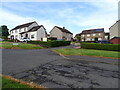
1
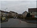
Firbank Terrace
Residential street in the Auchenback area of Barrhead.
Image: © Stephen Sweeney
Taken: 24 Mar 2010
0.04 miles
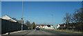
2
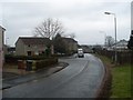
Springfield Drive, Auchenback
At the southeast edge of the town of Barrhead.
Image: © Stephen Sweeney
Taken: 24 Mar 2010
0.07 miles
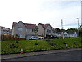
5
Close by Barrhead
Barrhead is one of the outer suburbs of Glasgow and is not where we intended to be, having taken a wrong turn many miles back.
Image: © Malcolm Neal
Taken: 20 Mar 2022
0.08 miles
7
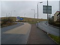
Between Springfield Drive and Aurs Road
In Barrhead. Looking west to the junction between Aurs Road and Springfield Road.
Image: © Stephen Sweeney
Taken: 24 Mar 2010
0.11 miles
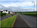
8

Aurs Road, Barrhead
Currently the boundary of the built up area.
Image: © Richard Webb
Taken: 25 Sep 2015
0.12 miles
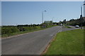
9
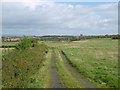
Track off Aurs Road
The edge of Barrhead.
Image: © Richard Webb
Taken: 25 Sep 2015
0.12 miles