IMAGES TAKEN NEAR TO
Aurs Crescent, GLASGOW, G78 2LU
Introduction
This page details the photographs taken nearby to Aurs Crescent, G78 2LU by members of the Geograph project.
The Geograph project started in 2005 with the aim of publishing, organising and preserving representative images for every square kilometre of Great Britain, Ireland and the Isle of Man.

There are currently over 7.5m images from over14,400 individuals and you can help contribute to the project by visiting https://www.geograph.org.uk
Image Map
Images are licensed for reuse under creativecommons.org/licenses/by-sa/2.0
Notes
- Clicking on the map will re-center to the selected point.
- The higher the marker number, the further away the image location is from the centre of the postcode.
Image Listing (14 Images Found)
Images are licensed for reuse under creativecommons.org/licenses/by-sa/2.0
Image
Details
Distance
2
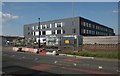
New building, Aurs Road
Just to the south of Barrhead High School. The building work started in 2016 and is nearing completion.
Image: © Richard Sutcliffe
Taken: 18 Jul 2017
0.03 miles
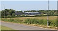
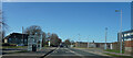
4
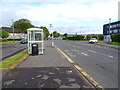
Bus stop and shelter on Aurs Road, Barrhead
Image: © JThomas
Taken: 24 May 2021
0.06 miles
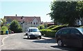
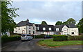
5
Junction of Aurs Place and Aurs Road
Aurs Place is a small cul-de-sac just off Aurs Road.
Image: © Richard Sutcliffe
Taken: 18 Jul 2017
0.06 miles
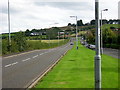
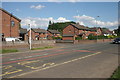
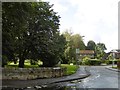
6
In Barrhead
Not much traffic on the road and even fewer people on the pavement!
Image: © Malcolm Neal
Taken: 20 Mar 2022
0.08 miles
7
Aursbridge Drive and Aursbridge Crescent
Off Aurs Road, Barrhead, opposite Barrhead High School.
Image: © Richard Webb
Taken: 25 Sep 2015
0.11 miles