IMAGES TAKEN NEAR TO
Divernia Way, GLASGOW, G78 2JP
Introduction
This page details the photographs taken nearby to Divernia Way, G78 2JP by members of the Geograph project.
The Geograph project started in 2005 with the aim of publishing, organising and preserving representative images for every square kilometre of Great Britain, Ireland and the Isle of Man.

There are currently over 7.5m images from over14,400 individuals and you can help contribute to the project by visiting https://www.geograph.org.uk
Image Map
Images are licensed for reuse under creativecommons.org/licenses/by-sa/2.0
Notes
- Clicking on the map will re-center to the selected point.
- The higher the marker number, the further away the image location is from the centre of the postcode.
Image Listing (4 Images Found)
Images are licensed for reuse under creativecommons.org/licenses/by-sa/2.0
Image
Details
Distance
1
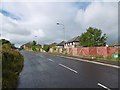
Edge of Barrhead
Houses on Springfield Road beyond the fence. Land to the left is not being farmed and will probably be built upon.
Image: © Richard Webb
Taken: 25 Sep 2015
0.06 miles
2
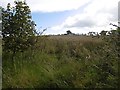
Abandoned farmland, Springhill
Hedges gone, fields overgrown - there is a large area of non farmed farmland here awaiting development.
Image: © Richard Webb
Taken: 25 Sep 2015
0.15 miles
3
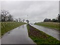
Balgraystone Road
Widened as part of large scale housing development in the area.
Image: © Richard Webb
Taken: 27 Apr 2021
0.20 miles
4
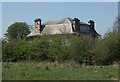
Rock Mount
Big house off Springfield Road, Barrhead.
Image: © Richard Sutcliffe
Taken: 9 May 2016
0.24 miles