IMAGES TAKEN NEAR TO
Killoch Drive, GLASGOW, G78 2HY
Introduction
This page details the photographs taken nearby to Killoch Drive, G78 2HY by members of the Geograph project.
The Geograph project started in 2005 with the aim of publishing, organising and preserving representative images for every square kilometre of Great Britain, Ireland and the Isle of Man.

There are currently over 7.5m images from over14,400 individuals and you can help contribute to the project by visiting https://www.geograph.org.uk
Image Map
Images are licensed for reuse under creativecommons.org/licenses/by-sa/2.0
Notes
- Clicking on the map will re-center to the selected point.
- The higher the marker number, the further away the image location is from the centre of the postcode.
Image Listing (7 Images Found)
Images are licensed for reuse under creativecommons.org/licenses/by-sa/2.0
Image
Details
Distance
1
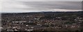
Barrhead panorama
The picture looks across Barrhead from low down on the Fereneze Hills, not far from the south edge of the golf course. Auchenback stands out to the left of the picture.
Image: © Alec MacKinnon
Taken: 26 Mar 2016
0.16 miles
2
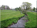
Aurs Burn in Auchenback Community Park
Small park in the heart of Auchenback, Barrhead.
Image: © G Laird
Taken: 30 Apr 2014
0.17 miles
3
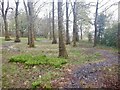
The Mill Run
Mountain bike track in the Aurs Glen
Image: © Richard Webb
Taken: 27 Apr 2021
0.18 miles
4
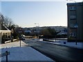
View southeast across Auchenback
From Cloth Street.
Image: © Stephen Sweeney
Taken: 6 Jan 2010
0.18 miles
5
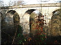
Disused railway viaduct
This, now disused, viaduct originally joined the Barrhead and Paisley railways to the Neilston line. Although intended, it was never used for passenger transport.
Image: © Mark Klimek
Taken: 9 Feb 2008
0.24 miles
6
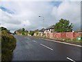
Edge of Barrhead
Houses on Springfield Road beyond the fence. Land to the left is not being farmed and will probably be built upon.
Image: © Richard Webb
Taken: 25 Sep 2015
0.24 miles
7
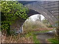
Aurs Glen viaduct
Carried the Caledonian Railway's Paisley and Barrhead line over the Aurs Glen. The line was a goods only route although passenger stations were built.
Image: © Richard Webb
Taken: 27 Apr 2021
0.24 miles