IMAGES TAKEN NEAR TO
Lowndes Court, GLASGOW, G78 2FF
Introduction
This page details the photographs taken nearby to Lowndes Court, G78 2FF by members of the Geograph project.
The Geograph project started in 2005 with the aim of publishing, organising and preserving representative images for every square kilometre of Great Britain, Ireland and the Isle of Man.

There are currently over 7.5m images from over14,400 individuals and you can help contribute to the project by visiting https://www.geograph.org.uk
Image Map
Images are licensed for reuse under creativecommons.org/licenses/by-sa/2.0
Notes
- Clicking on the map will re-center to the selected point.
- The higher the marker number, the further away the image location is from the centre of the postcode.
Image Listing (37 Images Found)
Images are licensed for reuse under creativecommons.org/licenses/by-sa/2.0
Image
Details
Distance
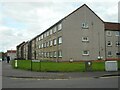
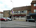
3
Aursbridge Drive and Aursbridge Crescent
Off Aurs Road, Barrhead, opposite Barrhead High School.
Image: © Richard Webb
Taken: 25 Sep 2015
0.15 miles
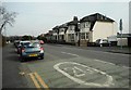
7
The Flying Horse
Public house in Barrhead.
Image: © Richard Sutcliffe
Taken: 5 May 2023
0.17 miles
8
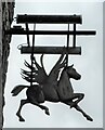
Sign for The Flying Horse
Public house in Barrhead Image
Image: © Richard Sutcliffe
Taken: 5 May 2023
0.17 miles