IMAGES TAKEN NEAR TO
Duncolm View, GLASGOW, G78 2BS
Introduction
This page details the photographs taken nearby to Duncolm View, G78 2BS by members of the Geograph project.
The Geograph project started in 2005 with the aim of publishing, organising and preserving representative images for every square kilometre of Great Britain, Ireland and the Isle of Man.

There are currently over 7.5m images from over14,400 individuals and you can help contribute to the project by visiting https://www.geograph.org.uk
Image Map
Images are licensed for reuse under creativecommons.org/licenses/by-sa/2.0
Notes
- Clicking on the map will re-center to the selected point.
- The higher the marker number, the further away the image location is from the centre of the postcode.
Image Listing (18 Images Found)
Images are licensed for reuse under creativecommons.org/licenses/by-sa/2.0
Image
Details
Distance
1
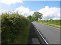
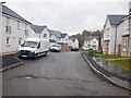
Springhill Road
Leaving Barrhead to the south.
Image: © Richard Webb
Taken: 25 Jun 2016
0.08 miles
2
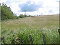
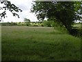
Field off Springhill Road
Field on the edge of Barrhead.
Image: © Richard Webb
Taken: 25 Jun 2016
0.09 miles
4
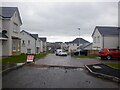
New houses, off Springhill Road
Taken during a forlorn foray looking for a way around the closure of Springfield Road. Eventually found a way through the woods to the Aurs Burn.
Image: © Richard Webb
Taken: 27 Apr 2021
0.12 miles
6
Field off Springhill Road
Grass crop south of Barrhead.
Image: © Richard Webb
Taken: 25 Jun 2016
0.13 miles
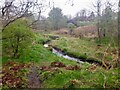
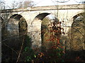
7
Aurs Glen viaduct
Carried the Caledonian Railway's Paisley and Barrhead line over the Aurs Glen. The line was a goods only route although passenger stations were built.
Image: © Richard Webb
Taken: 27 Apr 2021
0.14 miles
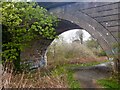
8
Disused railway viaduct
This, now disused, viaduct originally joined the Barrhead and Paisley railways to the Neilston line. Although intended, it was never used for passenger transport.
Image: © Mark Klimek
Taken: 9 Feb 2008
0.14 miles
9
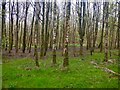
Woodland, north of Springfield Road
Almost surrounded by new houses, and building sites.
Image: © Richard Webb
Taken: 27 Apr 2021
0.17 miles
10
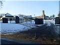
Springhill Primary School, Barrhead
In the south of the town.
Image: © Stephen Sweeney
Taken: 6 Jan 2010
0.17 miles