IMAGES TAKEN NEAR TO
Grahamston Road, GLASGOW, G78 1NS
Introduction
This page details the photographs taken nearby to Grahamston Road, G78 1NS by members of the Geograph project.
The Geograph project started in 2005 with the aim of publishing, organising and preserving representative images for every square kilometre of Great Britain, Ireland and the Isle of Man.

There are currently over 7.5m images from over14,400 individuals and you can help contribute to the project by visiting https://www.geograph.org.uk
Image Map
Images are licensed for reuse under creativecommons.org/licenses/by-sa/2.0
Notes
- Clicking on the map will re-center to the selected point.
- The higher the marker number, the further away the image location is from the centre of the postcode.
Image Listing (20 Images Found)
Images are licensed for reuse under creativecommons.org/licenses/by-sa/2.0
Image
Details
Distance
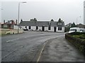
2
The Cross Stobs Inn, Barrhead
On Grahamston Road.
Image: © JThomas
Taken: 24 May 2021
0.02 miles
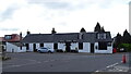
3

Road Junction on Paisley Road, Barrhead
Both roads at the fork lead towards Paisley.
Image: © G Laird
Taken: 29 Apr 2014
0.02 miles
4

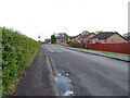
Grahamston Road
Looking towards the houses of Boylestone on the edge of Barrhead.
Image: © Richard Sutcliffe
Taken: 4 Jan 2017
0.02 miles

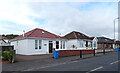
7
Grahamston Road housing
In Barrhead.
Image: © Stephen Sweeney
Taken: 12 Aug 2009
0.09 miles
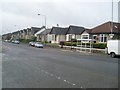
9
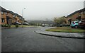
Grahamston Park
A quiet residential street on a misty day.
Image: © Richard Sutcliffe
Taken: 28 Apr 2023
0.10 miles
10
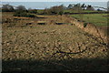
The view through the hedge
Looking through the leafless hawthorn hedge across fields to the northwest of Grahamston Road.
Image: © Richard Sutcliffe
Taken: 4 Jan 2017
0.12 miles