IMAGES TAKEN NEAR TO
Orchid Way, GLASGOW, G78 1FJ
Introduction
This page details the photographs taken nearby to Orchid Way, G78 1FJ by members of the Geograph project.
The Geograph project started in 2005 with the aim of publishing, organising and preserving representative images for every square kilometre of Great Britain, Ireland and the Isle of Man.

There are currently over 7.5m images from over14,400 individuals and you can help contribute to the project by visiting https://www.geograph.org.uk
Image Map
Images are licensed for reuse under creativecommons.org/licenses/by-sa/2.0
Notes
- Clicking on the map will re-center to the selected point.
- The higher the marker number, the further away the image location is from the centre of the postcode.
Image Listing (25 Images Found)
Images are licensed for reuse under creativecommons.org/licenses/by-sa/2.0
Image
Details
Distance
2
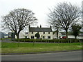
Former course of a railway line
The view is from Grahamston Road, almost opposite the junction with Blackbyres Road. A pylon can be seen in the distance. What probably caught my attention here, as seeming subtly wrong or out-of-place, was the lines of trees on each side: though it is hard to discern from here, where they are seen receding into the distance, both lines are in fact parallel to the direction of view.
Reference to old maps reveals that those lines of trees correspond to the sides of what was once the course of a railway line. The photograph is therefore a view directly down the former course of that line, which is now long gone: it was already marked as a "dismantled railway line" on the OS map revision of 1947, though an adjacent line just to the south was then still in existence.
An earlier OS map revision of 1911—12 labels the line whose former course is shown in my picture "G. & S.W.R. Paisley & Barrhead Branch", while the one immediately to the south of it, which survived a little longer, is annotated "C.R. Paisley & Barrhead Line" (and "L.M.S.R. Paisley & Barrhead Line" on the 1947 map).
Image: © Lairich Rig
Taken: 26 Aug 2019
0.14 miles
3
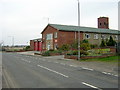
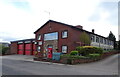
Barrhead Community Fire Station
On Grahamston Road at the northern edge of Barrhead.
Image: © Richard Sutcliffe
Taken: 28 Apr 2023
0.14 miles
4
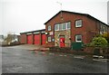
Barrhead Community Fire Station
On Grahamston Road at the northern edge of Barrhead.
Image: © Richard Sutcliffe
Taken: 28 Apr 2023
0.14 miles
5
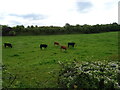
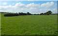
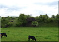
Cattle grazing near old railway embankment
Off Grahamston Road.
Image: © JThomas
Taken: 24 May 2021
0.14 miles
6
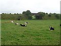
Cows in field and tunnels
The small tunnel allows Harelaw Burn to pass beneath a former railway embankment. The larger tunnel took a different railway line under the embankment.
Image: © Stephen Sweeney
Taken: 12 Aug 2009
0.15 miles
7
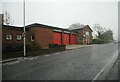
Barrhead Community Fire Station
On Grahamston Road.
Image: © JThomas
Taken: 24 May 2021
0.15 miles
9
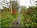
Track just off Grahamston Road
The track runs along the back of the modern properties on Grahamston Park. The OS 25 inch maps surveyed in 1857, 1897, 1910 and 1934 all show the line of the track marked as a strip of woodland, following field edges, but the 1:1,250/1:2,500 map of 1949-1956 shows it is a track. Today it is more a path than a track and has many trees along its length once again.
Image: © Richard Sutcliffe
Taken: 28 Apr 2023
0.16 miles
10
Old railway bridge
Farm access under an old mineral line.
Image: © JThomas
Taken: 24 May 2021
0.16 miles