IMAGES TAKEN NEAR TO
Stewart Street, GLASGOW, G78 1AL
Introduction
This page details the photographs taken nearby to Stewart Street, G78 1AL by members of the Geograph project.
The Geograph project started in 2005 with the aim of publishing, organising and preserving representative images for every square kilometre of Great Britain, Ireland and the Isle of Man.

There are currently over 7.5m images from over14,400 individuals and you can help contribute to the project by visiting https://www.geograph.org.uk
Image Map
Images are licensed for reuse under creativecommons.org/licenses/by-sa/2.0
Notes
- Clicking on the map will re-center to the selected point.
- The higher the marker number, the further away the image location is from the centre of the postcode.
Image Listing (6 Images Found)
Images are licensed for reuse under creativecommons.org/licenses/by-sa/2.0
Image
Details
Distance
1
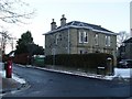
House at the corner of Carlibar Road and Commercial Road
In Barrhead.
Image: © Stephen Sweeney
Taken: 6 Jan 2010
0.10 miles
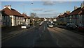
2
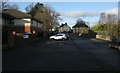
Carlibar Road, Barrhead
The building on the left is a BUPA care home.
Image: © Richard Sutcliffe
Taken: 4 Jan 2017
0.23 miles
3
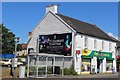
Day-Today express, Glasgow Road, Barrhead
Image: © Leslie Barrie
Taken: 9 Jul 2014
0.24 miles
4
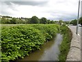
Levern Water
Infestation of Japanese Knotweed in Barrhead.
Image: © Richard Webb
Taken: 25 Jun 2016
0.24 miles
5
A736, Dovecothall Street, Barrhead
Looking from the Dovecothall Roundabout.
Image: © Richard Sutcliffe
Taken: 4 Jan 2017
0.25 miles
6
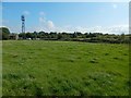
Dismantled railway line
The line ran on the embankment in the background. Behind that, but hidden by the embankment itself, is what was formerly Shanks Industrial Park (Shanks of Braehead, as in "Armitage Shanks"), set to be redeveloped as housing.
Image: © Lairich Rig
Taken: 26 Aug 2019
0.25 miles