IMAGES TAKEN NEAR TO
Ladeside Close, GLASGOW, G77 6TZ
Introduction
This page details the photographs taken nearby to Ladeside Close, G77 6TZ by members of the Geograph project.
The Geograph project started in 2005 with the aim of publishing, organising and preserving representative images for every square kilometre of Great Britain, Ireland and the Isle of Man.

There are currently over 7.5m images from over14,400 individuals and you can help contribute to the project by visiting https://www.geograph.org.uk
Image Map
Images are licensed for reuse under creativecommons.org/licenses/by-sa/2.0
Notes
- Clicking on the map will re-center to the selected point.
- The higher the marker number, the further away the image location is from the centre of the postcode.
Image Listing (22 Images Found)
Images are licensed for reuse under creativecommons.org/licenses/by-sa/2.0
Image
Details
Distance
1
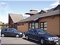
Newton Mearns Baptist Church
Greenfarm Road, Newton Mearns
Image: © G McK
Taken: 3 Jul 2005
0.07 miles

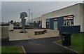
5
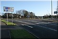
Crookfur Roundabout
The roundabout is at the junction of the B769 (Stewarton Road), the B7087 and Crookfur Road.
Image: © Richard Sutcliffe
Taken: 8 Dec 2017
0.09 miles
6
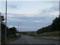
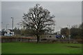
Sunset over Stewarton Road, Newton Mearns
Image: © Peter Whatley
Taken: 21 Sep 2015
0.10 miles
7
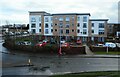
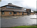
Greenwood Grove West
Retirement apartments built by McCarthy & Stone.
Image: © Richard Sutcliffe
Taken: 15 Feb 2023
0.12 miles
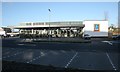
10
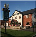
The Capelrig, Newton Mearns
A 'Hungry Horse' pub and restaurant.
Image: © Richard Sutcliffe
Taken: 8 Dec 2017
0.16 miles