IMAGES TAKEN NEAR TO
Lewis Place, GLASGOW, G77 6TG
Introduction
This page details the photographs taken nearby to Lewis Place, G77 6TG by members of the Geograph project.
The Geograph project started in 2005 with the aim of publishing, organising and preserving representative images for every square kilometre of Great Britain, Ireland and the Isle of Man.

There are currently over 7.5m images from over14,400 individuals and you can help contribute to the project by visiting https://www.geograph.org.uk
Image Map
Images are licensed for reuse under creativecommons.org/licenses/by-sa/2.0
Notes
- Clicking on the map will re-center to the selected point.
- The higher the marker number, the further away the image location is from the centre of the postcode.
Image Listing (9 Images Found)
Images are licensed for reuse under creativecommons.org/licenses/by-sa/2.0
Image
Details
Distance
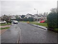
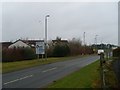
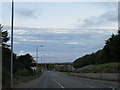
2
Jura Drive
Looking towards the B769, Stewarton Road.
Image: © Richard Sutcliffe
Taken: 8 Dec 2017
0.09 miles
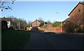
3
Stewartson Road after rain
Always seems to rain when in Scotland
Image: © Josie Campbell
Taken: 7 Jan 2012
0.15 miles
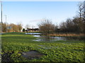
4
Approaching Westacres Roundabout
In Newton Mearns, by the M77.
Image: © Stephen Sweeney
Taken: 24 Mar 2010
0.21 miles
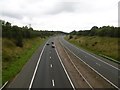
5
Mobile phone mast and M77
From Aurs Road. Both are clearly visible on the OS map.
Image: © Stephen Sweeney
Taken: 24 Mar 2010
0.22 miles
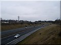
6
M77
Ayrshire to Glasgow motorway descends past Newton Mearns.
Image: © Richard Webb
Taken: 28 Aug 2016
0.24 miles
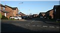
7
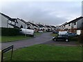
Lochinch Place
Residential cul-de-sac in the south of Newton Mearns.
Image: © Alec MacKinnon
Taken: 9 Feb 2023
0.24 miles
8
Sunset over Stewarton Road, Newton Mearns
Image: © Peter Whatley
Taken: 21 Sep 2015
0.24 miles