IMAGES TAKEN NEAR TO
Newton Mearns, GLASGOW, G77 6SH
Introduction
This page details the photographs taken nearby to G77 6SH by members of the Geograph project.
The Geograph project started in 2005 with the aim of publishing, organising and preserving representative images for every square kilometre of Great Britain, Ireland and the Isle of Man.

There are currently over 7.5m images from over14,400 individuals and you can help contribute to the project by visiting https://www.geograph.org.uk
Image Map
Images are licensed for reuse under creativecommons.org/licenses/by-sa/2.0
Notes
- Clicking on the map will re-center to the selected point.
- The higher the marker number, the further away the image location is from the centre of the postcode.
Image Listing (5 Images Found)
Images are licensed for reuse under creativecommons.org/licenses/by-sa/2.0
Image
Details
Distance
3
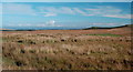
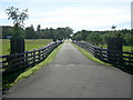
Shieldhill Farm
Rough grazing, and the outskirts of Glasgow just visible in the centre distance.
Image: © Mary and Angus Hogg
Taken: 3 Oct 2006
0.10 miles
5
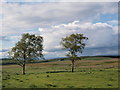
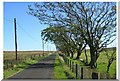
Two trees on Eaglesham Moorland
The trees sit beside the minor road that runs between the A77 at Floak Bridge and the house called Kingswell on the Eaglesham Moor road. They are seen here from the south. There are not so many trees in this high, rather bleak moorland - apart from the comparatively recent commercial forests. The surrounding terrain is typical of the Eaglesham Moor, boggy grassland.
Image: © Alec MacKinnon
Taken: 9 Jun 2019
0.16 miles