IMAGES TAKEN NEAR TO
Hazelden Road, GLASGOW, G77 6RR
Introduction
This page details the photographs taken nearby to Hazelden Road, G77 6RR by members of the Geograph project.
The Geograph project started in 2005 with the aim of publishing, organising and preserving representative images for every square kilometre of Great Britain, Ireland and the Isle of Man.

There are currently over 7.5m images from over14,400 individuals and you can help contribute to the project by visiting https://www.geograph.org.uk
Image Map
Images are licensed for reuse under creativecommons.org/licenses/by-sa/2.0
Notes
- Clicking on the map will re-center to the selected point.
- The higher the marker number, the further away the image location is from the centre of the postcode.
Image Listing (11 Images Found)
Images are licensed for reuse under creativecommons.org/licenses/by-sa/2.0
Image
Details
Distance

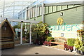
3

Felled trees, Caulders Braidbar Garden Centre
A large number of trees have recently been felled beside Caulders Braidbar Garden Centre for safety reasons. This is apparently because many of the trees have been growing on a steep slope, and their roots have loosened pieces of rock, some of which have fallen onto cars below. A member of staff explained that they are intending to replant about 800 trees to replace those cut down.
Image: © Richard Sutcliffe
Taken: 9 Jan 2020
0.08 miles
4

Standing stone, Caulders Braidbar Garden Centre
Known as the Gowkstone, according to Canmore https://canmore.org.uk/site/305132/gowkstone, this stone may have been inserted into the top of a small knoll in Hazeldean House garden as a feature.
Image: © Richard Sutcliffe
Taken: 9 Jan 2020
0.08 miles
5
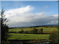
Ruin and Farm Storage
Ruin and farm storage south of Newton Mearns
Image: © Iain Thompson
Taken: 15 Sep 2006
0.13 miles
6
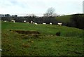
Field with sheep
Just north of Mearns Road.
Image: © Richard Sutcliffe
Taken: 9 Jan 2020
0.13 miles
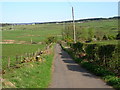
7
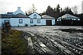
Hazeltonhead
On Mearns Road. Originally a farmhouse, the cluster of buildings now appear to be in residential use.
Image: © Richard Sutcliffe
Taken: 9 Jan 2020
0.14 miles
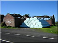
8
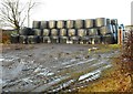
Lots of bales
The ruined farm buildings which used to be here Image have been demolished, but there are still round bales wrapped in polythene stored here.
Image: © Richard Sutcliffe
Taken: 9 Jan 2020
0.16 miles