IMAGES TAKEN NEAR TO
Craigton Road, GLASGOW, G77 6QE
Introduction
This page details the photographs taken nearby to Craigton Road, G77 6QE by members of the Geograph project.
The Geograph project started in 2005 with the aim of publishing, organising and preserving representative images for every square kilometre of Great Britain, Ireland and the Isle of Man.

There are currently over 7.5m images from over14,400 individuals and you can help contribute to the project by visiting https://www.geograph.org.uk
Image Map
Images are licensed for reuse under creativecommons.org/licenses/by-sa/2.0
Notes
- Clicking on the map will re-center to the selected point.
- The higher the marker number, the further away the image location is from the centre of the postcode.
Image Listing (9 Images Found)
Images are licensed for reuse under creativecommons.org/licenses/by-sa/2.0
Image
Details
Distance
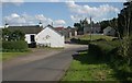
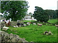
2
Craigton Farm
Looking across Walton Burn from Craigton Road.
Image: © G Laird
Taken: 2 May 2014
0.05 miles
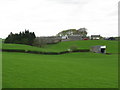
3
Dam, South Craigton
Site of a reservoir, now decommissioned.
Image: © Richard Webb
Taken: 25 Jun 2016
0.06 miles
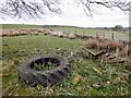
5
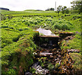
Old Dam, South Craigton
The Walton Burn was used to create this small disused reservoir.
Image: © wfmillar
Taken: 20 May 2011
0.08 miles
7
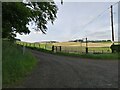
Middleton road end
The farm road going to Middleton starts here.
Image: © Alec MacKinnon
Taken: 30 Jun 2021
0.13 miles
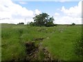
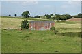
8
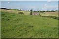
Fields beside South Craigton
The rusty shed is in the adjacent square.
Image: © Richard Sutcliffe
Taken: 18 Jul 2017
0.14 miles