IMAGES TAKEN NEAR TO
Newton Mearns, GLASGOW, G77 6QA
Introduction
This page details the photographs taken nearby to G77 6QA by members of the Geograph project.
The Geograph project started in 2005 with the aim of publishing, organising and preserving representative images for every square kilometre of Great Britain, Ireland and the Isle of Man.

There are currently over 7.5m images from over14,400 individuals and you can help contribute to the project by visiting https://www.geograph.org.uk
Image Map
Images are licensed for reuse under creativecommons.org/licenses/by-sa/2.0
Notes
- Clicking on the map will re-center to the selected point.
- The higher the marker number, the further away the image location is from the centre of the postcode.
Image Listing (15 Images Found)
Images are licensed for reuse under creativecommons.org/licenses/by-sa/2.0
Image
Details
Distance
1
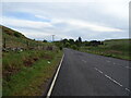
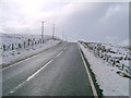
B769 near Middleton Wind Farm
Looking towards Glasgow.
Image: © Richard Sutcliffe
Taken: 16 Aug 2016
0.13 miles
2
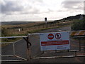
Start of the road to Bannerbank Quarry
Image: © Alec MacKinnon
Taken: 11 Oct 2019
0.14 miles
3

Highland cattle at Bannerbank Farm
Looking sleekit in the rain.
Image: © John Allan
Taken: 11 Oct 2006
0.15 miles
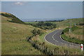
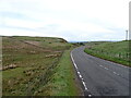
5
B769
A remote section of the B769 heading for Stewarton.
Image: © Mark Nightingale
Taken: 4 Mar 2009
0.17 miles
6
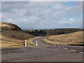
B769 at the entrance to Middleton Windfarm
The windfarm access road heads up the hill to the left. The picture looks north towards Glasgow.
Image: © Alec MacKinnon
Taken: 24 Mar 2021
0.17 miles
8
B769 near Bannerbank Quarry
Towards Glasgow.
Image: © JThomas
Taken: 24 May 2021
0.20 miles
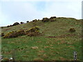
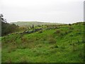
9
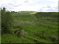
Rough pasture near Dodside
Off the B769.
Image: © Richard Webb
Taken: 25 Jun 2016
0.20 miles