IMAGES TAKEN NEAR TO
Stewarton Road, GLASGOW, G77 6PU
Introduction
This page details the photographs taken nearby to Stewarton Road, G77 6PU by members of the Geograph project.
The Geograph project started in 2005 with the aim of publishing, organising and preserving representative images for every square kilometre of Great Britain, Ireland and the Isle of Man.

There are currently over 7.5m images from over14,400 individuals and you can help contribute to the project by visiting https://www.geograph.org.uk
Image Map
Images are licensed for reuse under creativecommons.org/licenses/by-sa/2.0
Notes
- Clicking on the map will re-center to the selected point.
- The higher the marker number, the further away the image location is from the centre of the postcode.
Image Listing (5 Images Found)
Images are licensed for reuse under creativecommons.org/licenses/by-sa/2.0
Image
Details
Distance
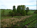
1
Roadside fields
The building visible behind the cattle is Langton Farm (in NS5054).
Image: © James Allan
Taken: 1 Jun 2012
0.18 miles
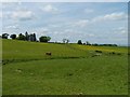
2
Grazing towards Langton Farm
Rough grazing gives way to more improved land on the other side of the Brock Burn.
Image: © JThomas
Taken: 24 May 2021
0.21 miles
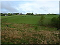
3
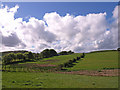
Farmland near Langton Farm
The picture looks across the fields towards Langton Farm from the side of Dodside Road opposite Faulds Farm road end.
Image: © Alec MacKinnon
Taken: 11 Oct 2019
0.23 miles
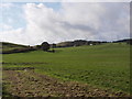
4
Farmland near Langton Farm
Brock Burn runs in the dip.
Image: © wfmillar
Taken: 20 May 2011
0.23 miles