IMAGES TAKEN NEAR TO
Pilmuir Road, GLASGOW, G77 6PS
Introduction
This page details the photographs taken nearby to Pilmuir Road, G77 6PS by members of the Geograph project.
The Geograph project started in 2005 with the aim of publishing, organising and preserving representative images for every square kilometre of Great Britain, Ireland and the Isle of Man.

There are currently over 7.5m images from over14,400 individuals and you can help contribute to the project by visiting https://www.geograph.org.uk
Image Map
Images are licensed for reuse under creativecommons.org/licenses/by-sa/2.0
Notes
- Clicking on the map will re-center to the selected point.
- The higher the marker number, the further away the image location is from the centre of the postcode.
Image Listing (7 Images Found)
Images are licensed for reuse under creativecommons.org/licenses/by-sa/2.0
Image
Details
Distance
1
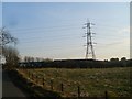
Pylon line crossing road at Pilmuir Holdings
Image: © Stephen Sweeney
Taken: 12 Apr 2010
0.04 miles
2
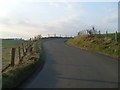
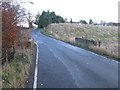
The winding road to Pilmuir Holdings
Just west of the town of Newton Mearns.
Image: © Stephen Sweeney
Taken: 12 Apr 2010
0.12 miles
3
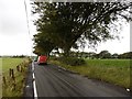
The Post, Pilmuir Holdings
Delivery on a rather busy yellow road.
Image: © Richard Webb
Taken: 25 Sep 2015
0.18 miles
4
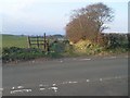
Path near Netherplace
Leads to Netherplace Farm from Pilmuir Holdings.
Image: © Stephen Sweeney
Taken: 12 Apr 2010
0.21 miles
7
Fauldsmeadon Bridge
The bridge spans Capelrig Burn just to the west of Newton Mearns.
Image: © G Laird
Taken: 12 Nov 2013
0.25 miles