IMAGES TAKEN NEAR TO
Netherplace Road, GLASGOW, G77 6PP
Introduction
This page details the photographs taken nearby to Netherplace Road, G77 6PP by members of the Geograph project.
The Geograph project started in 2005 with the aim of publishing, organising and preserving representative images for every square kilometre of Great Britain, Ireland and the Isle of Man.

There are currently over 7.5m images from over14,400 individuals and you can help contribute to the project by visiting https://www.geograph.org.uk
Image Map
Images are licensed for reuse under creativecommons.org/licenses/by-sa/2.0
Notes
- Clicking on the map will re-center to the selected point.
- The higher the marker number, the further away the image location is from the centre of the postcode.
Image Listing (8 Images Found)
Images are licensed for reuse under creativecommons.org/licenses/by-sa/2.0
Image
Details
Distance
1
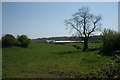
Works off Netherplace Road
Looking south-east across fields towards what is marked on the map as a 'works'. It is not clear exactly what kind of works.
Image: © Richard Sutcliffe
Taken: 9 May 2016
0.07 miles
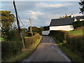
3

Looking down Dodside Road
The view looks down Dodside Road from just south of Newtown Mearns as one travels north, generally towards Glasgow. A heavy rain shower which had passed across the city from the west is still seen to the right.
Image: © Alec MacKinnon
Taken: 3 Sep 2020
0.21 miles
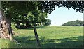
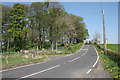
4
Looking uphill to Lofts
A spot typical of this meandering minor road on the south edge of Newton Mearns, here climbing uphill to the house named Lofts that sits on a sharp corner.
Image: © Alec MacKinnon
Taken: 8 Oct 2021
0.21 miles
5
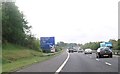
Warning sign for junction 5 -1 mile ahead
Image: © John Firth
Taken: 15 May 2014
0.22 miles
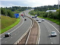
6
Approaching the reservoirs
The B769 passes by a couple of small reservoirs just up ahead.
Image: © Malcolm Neal
Taken: 20 Mar 2022
0.23 miles
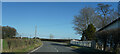
8
Junction on B769
Fingalton Road, on the left joins Stewarton Road (B769).
Image: © Richard Sutcliffe
Taken: 9 May 2016
0.24 miles