IMAGES TAKEN NEAR TO
Capelrig Road, GLASGOW, G77 6LE
Introduction
This page details the photographs taken nearby to Capelrig Road, G77 6LE by members of the Geograph project.
The Geograph project started in 2005 with the aim of publishing, organising and preserving representative images for every square kilometre of Great Britain, Ireland and the Isle of Man.

There are currently over 7.5m images from over14,400 individuals and you can help contribute to the project by visiting https://www.geograph.org.uk
Image Map
Images are licensed for reuse under creativecommons.org/licenses/by-sa/2.0
Notes
- Clicking on the map will re-center to the selected point.
- The higher the marker number, the further away the image location is from the centre of the postcode.
Image Listing (10 Images Found)
Images are licensed for reuse under creativecommons.org/licenses/by-sa/2.0
Image
Details
Distance
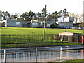
1
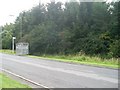
Bus stop on Capelrig Road
Next to woodland at Crookfur.
Image: © Stephen Sweeney
Taken: 29 Jul 2009
0.04 miles
2
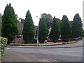
Trees surround house on Capelrig Road
In Crookfur.
Image: © Stephen Sweeney
Taken: 29 Jul 2009
0.06 miles
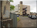
5
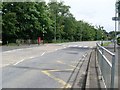
Zebra crossing at entrance to Eastwood High School
Across Capelrig Road.
Image: © Stephen Sweeney
Taken: 29 Jul 2009
0.16 miles
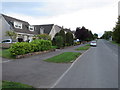
8
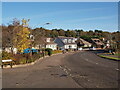
Harvie Avenue at Rannoch Avenue
Quiet suburban street scene typical of Newton Mearns on a weekday morning.
Image: © Alec MacKinnon
Taken: 18 Oct 2022
0.23 miles
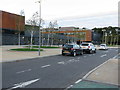
10
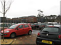
Eastwood High School
A view of the side of the school taken from Capelrig Road
Image: © G McK
Taken: 9 Jun 2005
0.24 miles