IMAGES TAKEN NEAR TO
Witchwood Grove, GLASGOW, G77 6GS
Introduction
This page details the photographs taken nearby to Witchwood Grove, G77 6GS by members of the Geograph project.
The Geograph project started in 2005 with the aim of publishing, organising and preserving representative images for every square kilometre of Great Britain, Ireland and the Isle of Man.

There are currently over 7.5m images from over14,400 individuals and you can help contribute to the project by visiting https://www.geograph.org.uk
Image Map
Images are licensed for reuse under creativecommons.org/licenses/by-sa/2.0
Notes
- Clicking on the map will re-center to the selected point.
- The higher the marker number, the further away the image location is from the centre of the postcode.
Image Listing (5 Images Found)
Images are licensed for reuse under creativecommons.org/licenses/by-sa/2.0
Image
Details
Distance
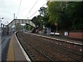
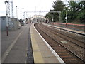
1
Patterton Station platform
The bridge carries Stewarton Road.
Image: © Alan Reid
Taken: 5 Nov 2018
0.21 miles
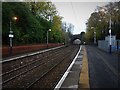
2
Patterton railway station, Renfrewshire
Opened in 1903 by the Lanarkshire and Ayrshire Railway on the line from Glasgow and Newton to Ardrossan. Since 1964, the line has only gone as far as Neilston, the next station west. View east towards Whitecraigs and Glasgow.
Image: © Nigel Thompson
Taken: 26 Mar 2011
0.23 miles