IMAGES TAKEN NEAR TO
Hillfield Brae, GLASGOW, G77 6GF
Introduction
This page details the photographs taken nearby to Hillfield Brae, G77 6GF by members of the Geograph project.
The Geograph project started in 2005 with the aim of publishing, organising and preserving representative images for every square kilometre of Great Britain, Ireland and the Isle of Man.

There are currently over 7.5m images from over14,400 individuals and you can help contribute to the project by visiting https://www.geograph.org.uk
Image Map
Images are licensed for reuse under creativecommons.org/licenses/by-sa/2.0
Notes
- Clicking on the map will re-center to the selected point.
- The higher the marker number, the further away the image location is from the centre of the postcode.
Image Listing (8 Images Found)
Images are licensed for reuse under creativecommons.org/licenses/by-sa/2.0
Image
Details
Distance
1
New houses beside Capelrig Road
The picture looks across the roundabout on Capelrig Road to new houses along Old Cadrig Way.
Image: © Alec MacKinnon
Taken: 18 Oct 2022
0.11 miles
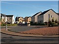
2
Greenwood Manor
New housing estate near to Patterton station.
Image: © Stephen Sweeney
Taken: 29 Jul 2009
0.16 miles
4
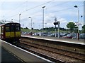
Neilston train leaves Patterton station
Onward to the final stop on the line.
Image: © Stephen Sweeney
Taken: 29 Jul 2009
0.22 miles
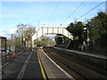
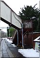
5
Patterton railway station
The penultimate station on the Neilston line, in the southern fringes of Glasgow.
Image: © Thomas Nugent
Taken: 30 Dec 2009
0.22 miles
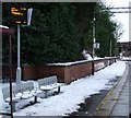
6
Patterton railway station
The penultimate station on the Neilston line, in the southern fringes of Glasgow.
Image: © Thomas Nugent
Taken: 30 Dec 2009
0.23 miles
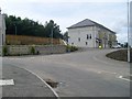
7
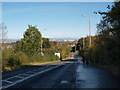
Stewarton Road near Patterton Station
The picture looks north along Stewarton Road to the roundabout where it meets Capelrig Road. Patterton rail station is just to the right of the road here.
Image: © Alec MacKinnon
Taken: 18 Oct 2022
0.24 miles