IMAGES TAKEN NEAR TO
Elmwood Avenue, GLASGOW, G77 6EH
Introduction
This page details the photographs taken nearby to Elmwood Avenue, G77 6EH by members of the Geograph project.
The Geograph project started in 2005 with the aim of publishing, organising and preserving representative images for every square kilometre of Great Britain, Ireland and the Isle of Man.

There are currently over 7.5m images from over14,400 individuals and you can help contribute to the project by visiting https://www.geograph.org.uk
Image Map
Images are licensed for reuse under creativecommons.org/licenses/by-sa/2.0
Notes
- Clicking on the map will re-center to the selected point.
- The higher the marker number, the further away the image location is from the centre of the postcode.
Image Listing (19 Images Found)
Images are licensed for reuse under creativecommons.org/licenses/by-sa/2.0
Image
Details
Distance
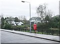
2
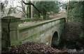
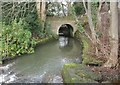
Bridge over Broom Burn
This sandstone bridge used to carry the driveway from the nearby main road to Broom House (now Belmont House School [http://www.geograph.org.uk/photo/5997611]). The driveway no longer exists and the bridge is out of use.
Image: © Richard Sutcliffe
Taken: 10 Dec 2018
0.15 miles
3
Sluice control
Mechanism for controlling the sluice at the northern end of the pond beside Broompark Drive.
Image: © Richard Sutcliffe
Taken: 10 Dec 2018
0.16 miles
4
Bridge over Broom Burn
This sandstone bridge used to carry the driveway from the nearby main road to Broom House (now Belmont House School [http://www.geograph.org.uk/photo/5997611]). The driveway no longer exists and the bridge is out of use.
Image: © Richard Sutcliffe
Taken: 10 Dec 2018
0.16 miles
5
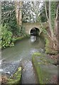
Bridge over Broom Burn
This sandstone bridge used to carry the driveway from the nearby main road to Broom House (now Belmont House School [http://www.geograph.org.uk/photo/5997611]). The driveway no longer exists and the bridge is out of use.
In the foreground is part of the spillway from the old curling pond to the south
Image: © Richard Sutcliffe
Taken: 10 Dec 2018
0.16 miles
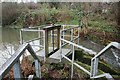
6
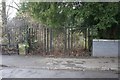
Gate beside old bridge, Broompark Drive
The railings and gate close off the old bridge over Broom Burn. This was the former driveway from the nearby main road to Broom House (now Belmont House School [http://www.geograph.org.uk/photo/5997611]).
Image: © Richard Sutcliffe
Taken: 10 Dec 2018
0.16 miles
7
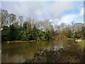
Pond on the Broom Burn
The heron on the far side of the pond seemed quite untroubled by the walkers on Broompark Drive and indeed the surrounding housing of this affluent suburban estate.
Image: © Alec MacKinnon
Taken: 10 Mar 2021
0.17 miles
8
Lifebelt beside the pond
The pond is beside Broompark Drive.
Image: © Richard Sutcliffe
Taken: 10 Dec 2018
0.18 miles
9
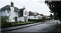
Houses on Broompark Drive
The houses overlook the old curling pond.
Image: © Richard Sutcliffe
Taken: 10 Dec 2018
0.18 miles