IMAGES TAKEN NEAR TO
Castle Road, GLASGOW, G77 6DQ
Introduction
This page details the photographs taken nearby to Castle Road, G77 6DQ by members of the Geograph project.
The Geograph project started in 2005 with the aim of publishing, organising and preserving representative images for every square kilometre of Great Britain, Ireland and the Isle of Man.

There are currently over 7.5m images from over14,400 individuals and you can help contribute to the project by visiting https://www.geograph.org.uk
Image Map
Images are licensed for reuse under creativecommons.org/licenses/by-sa/2.0
Notes
- Clicking on the map will re-center to the selected point.
- The higher the marker number, the further away the image location is from the centre of the postcode.
Image Listing (19 Images Found)
Images are licensed for reuse under creativecommons.org/licenses/by-sa/2.0
Image
Details
Distance
2
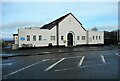
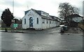
The Fairweather Hall
The hall is operated by East Renfrewshire Council. It is used by the community for a number of activities including meetings, children’s dance classes and social functions.
Sir Wallace Fairweather took a keen interest in Newton Mearns and in 1933 he gave £1000 for the building of the Fairweather Hall which opened on 25th November 1933 as a social and recreational centre for the village. (Information from Mearns History Group https://mearnshistory.org.uk/index.php/history/people. )
Image: © Richard Sutcliffe
Taken: 15 Feb 2023
0.17 miles
3
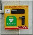
Defibrillator
Beside the door to the Fairweather Hall on Barrhead Road Image
Image: © Richard Sutcliffe
Taken: 15 Feb 2023
0.17 miles
4
Orchard Park Nursery
Children's nursery on Barrhead Road. The building was originally St Cadoc's RC chapel and dates from the early 20th century. A new St Cadoc's Church was opened elsewhere in Newton Mearns in 1981.
Image: © Richard Sutcliffe
Taken: 15 Feb 2023
0.17 miles
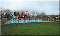
5
Play area
A small play area behind houses on Mallots View.
Image: © Richard Sutcliffe
Taken: 15 Feb 2023
0.18 miles
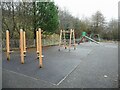
6
Children's swing park
In Fairweather Park.
Image: © Richard Sutcliffe
Taken: 15 Feb 2023
0.20 miles
7
Fairweather Park
Beside the park is Fordyce Court, a retirement housing complex run by East Renfrewshire Council.
Image: © Richard Sutcliffe
Taken: 15 Feb 2023
0.20 miles
8
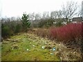
The path goes no further
A short path from Barrhead Road leads no further than here, so there is no access to the Capelrig Burn just beyond the scrub. The area appears to have attracted quite a lot of litter.
Image: © Richard Sutcliffe
Taken: 15 Feb 2023
0.20 miles
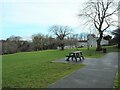
9
Seats with a view
Seats and picnic table in Fairwesther Park, with a view looking over Newton Mearns and parts of Glasgow to the Kilpatrick Hills and Campsie Fells.
Image: © Richard Sutcliffe
Taken: 15 Feb 2023
0.21 miles
10
Mearns Park
Also known as Fairweather Park this small park sits in an elevated position just across Capelrig Road from the car park for the Avenue shopping centre.
Image: © Alec MacKinnon
Taken: 26 Jan 2021
0.21 miles