IMAGES TAKEN NEAR TO
William Mann Drive, GLASGOW, G77 6DA
Introduction
This page details the photographs taken nearby to William Mann Drive, G77 6DA by members of the Geograph project.
The Geograph project started in 2005 with the aim of publishing, organising and preserving representative images for every square kilometre of Great Britain, Ireland and the Isle of Man.

There are currently over 7.5m images from over14,400 individuals and you can help contribute to the project by visiting https://www.geograph.org.uk
Image Map
Images are licensed for reuse under creativecommons.org/licenses/by-sa/2.0
Notes
- Clicking on the map will re-center to the selected point.
- The higher the marker number, the further away the image location is from the centre of the postcode.
Image Listing (12 Images Found)
Images are licensed for reuse under creativecommons.org/licenses/by-sa/2.0
Image
Details
Distance
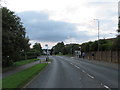
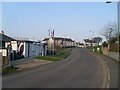
2
Hunter Drive
A distribution road for the infill housing between Newton Mearns and the M77.
Image: © Richard Webb
Taken: 27 Apr 2021
0.17 miles
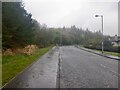
3

Play area
A small play area behind houses on Mallots View.
Image: © Richard Sutcliffe
Taken: 15 Feb 2023
0.17 miles
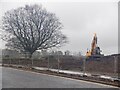
4
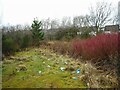
The path goes no further
A short path from Barrhead Road leads no further than here, so there is no access to the Capelrig Burn just beyond the scrub. The area appears to have attracted quite a lot of litter.
Image: © Richard Sutcliffe
Taken: 15 Feb 2023
0.19 miles
5
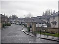
Manderston Meadow
Infill between Newton Mearns and the M77.
Image: © Richard Webb
Taken: 27 Apr 2021
0.19 miles
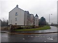
6
Ongoing development in Newton Mearns
In the Malletsheugh area at the top of Hunter Road.
Image: © Stephen Sweeney
Taken: 12 Apr 2010
0.22 miles
9
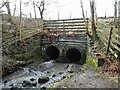
The Capelrig Burn emerges
The burn exits a large double culvert, having just passed under Barrhead Road.
Image: © Richard Sutcliffe
Taken: 15 Feb 2023
0.23 miles
10
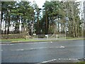
The entrance to Cadoc Wood
A path/cyclepath (the Capelrig Way) runs through the wood from here at Barrhead Road to Crookfur Road, following the Capelrig Burn.
Image: © Richard Sutcliffe
Taken: 15 Feb 2023
0.24 miles