IMAGES TAKEN NEAR TO
Ayr Road, GLASGOW, G77 6AH
Introduction
This page details the photographs taken nearby to Ayr Road, G77 6AH by members of the Geograph project.
The Geograph project started in 2005 with the aim of publishing, organising and preserving representative images for every square kilometre of Great Britain, Ireland and the Isle of Man.

There are currently over 7.5m images from over14,400 individuals and you can help contribute to the project by visiting https://www.geograph.org.uk
Image Map
Images are licensed for reuse under creativecommons.org/licenses/by-sa/2.0
Notes
- Clicking on the map will re-center to the selected point.
- The higher the marker number, the further away the image location is from the centre of the postcode.
Image Listing (17 Images Found)
Images are licensed for reuse under creativecommons.org/licenses/by-sa/2.0
Image
Details
Distance
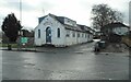
2
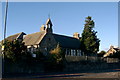
Mearns Primary School, Newton Mearns, near Glasgow
A quote from a recent copy of The Evening Times:
"The 127 year old former Mearns Primary School on Ayr Road, now under imminent threat of demolition to make way for car parking for the adjacent Avenue Shopping Centre. This has provoked a local protest campaign to save the school as part of the heritage of the village."
Image: © L J Cunningham
Taken: 1 Oct 2005
0.05 miles
3
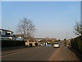
Paidmyre Road, Newton Mearns
Residential area in the south of the town.
Image: © Stephen Sweeney
Taken: 12 Apr 2010
0.09 miles
4
Paidmyre Road
East view from the top of Langrig Road.
Image: © Stephen Sweeney
Taken: 12 Apr 2010
0.20 miles
5
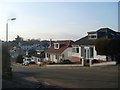
Orchard Park Nursery
Children's nursery on Barrhead Road. The building was originally St Cadoc's RC chapel and dates from the early 20th century. A new St Cadoc's Church was opened elsewhere in Newton Mearns in 1981.
Image: © Richard Sutcliffe
Taken: 15 Feb 2023
0.20 miles
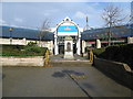
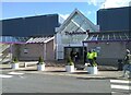
7
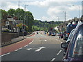
The Avenue Shopping Centre
Shopping centre entrance at Mearns Cross.
Image: © Mark Nightingale
Taken: 27 Jan 2010
0.21 miles
8
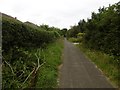
Langrig Road
This old road, now a tarred path was once the driveway to Langrig House. It is now a connecting route between the new houses of Newton Grove and Kirklands.
Image: © Richard Webb
Taken: 28 Aug 2016
0.21 miles
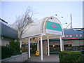
9
The Avenue shopping centre
The west entrance to the shopping centre from the car park off Barrhead Road.
Image: © Richard Sutcliffe
Taken: 7 Mar 2022
0.22 miles
10
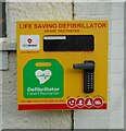
Defibrillator
Beside the door to the Fairweather Hall on Barrhead Road Image
Image: © Richard Sutcliffe
Taken: 15 Feb 2023
0.22 miles