IMAGES TAKEN NEAR TO
Callanish Crescent, GLASGOW, G77 5WT
Introduction
This page details the photographs taken nearby to Callanish Crescent, G77 5WT by members of the Geograph project.
The Geograph project started in 2005 with the aim of publishing, organising and preserving representative images for every square kilometre of Great Britain, Ireland and the Isle of Man.

There are currently over 7.5m images from over14,400 individuals and you can help contribute to the project by visiting https://www.geograph.org.uk
Image Map
Images are licensed for reuse under creativecommons.org/licenses/by-sa/2.0
Notes
- Clicking on the map will re-center to the selected point.
- The higher the marker number, the further away the image location is from the centre of the postcode.
Image Listing (7 Images Found)
Images are licensed for reuse under creativecommons.org/licenses/by-sa/2.0
Image
Details
Distance
1

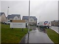
New houses, Maidenhill
A few are still under construction. Seen from Caulders Braidbar Garden Centre Image
Image: © Richard Sutcliffe
Taken: 9 Jan 2020
0.04 miles
5
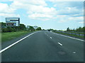
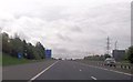
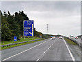
Approaching the Glasgow South Orbital road
Motorists heading along the A77 to join the South Orbital Road (A726) at its western terminus arrive along the road shown here.
Image: © Alec MacKinnon
Taken: 30 Mar 2014
0.24 miles
7
Maidenhill
Big housing development, Newton Mearns.
Image: © Richard Webb
Taken: 27 Apr 2021
0.25 miles