IMAGES TAKEN NEAR TO
Blair Atholl Gate, GLASGOW, G77 5UP
Introduction
This page details the photographs taken nearby to Blair Atholl Gate, G77 5UP by members of the Geograph project.
The Geograph project started in 2005 with the aim of publishing, organising and preserving representative images for every square kilometre of Great Britain, Ireland and the Isle of Man.

There are currently over 7.5m images from over14,400 individuals and you can help contribute to the project by visiting https://www.geograph.org.uk
Image Map
Images are licensed for reuse under creativecommons.org/licenses/by-sa/2.0
Notes
- Clicking on the map will re-center to the selected point.
- The higher the marker number, the further away the image location is from the centre of the postcode.
Image Listing (6 Images Found)
Images are licensed for reuse under creativecommons.org/licenses/by-sa/2.0
Image
Details
Distance
1

Muddy path
Leading from Barronsfield Grange to Waterfoot Road at King Henry's Knowe.
Image: © Richard Sutcliffe
Taken: 15 Feb 2023
0.19 miles
2
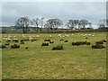
Grazing sheep
In a field north of Waterfoot Road.
Image: © Richard Sutcliffe
Taken: 15 Feb 2023
0.21 miles
3

Mearns Castle Trig Point
The trig point is situated beside Mearns Castle High School and from here there is a good view over Newton Mearns towards the Campsie Fells in the distance.
Image: © G Laird
Taken: 1 Jan 2013
0.23 miles
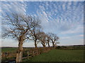
5

Farm track
We look along the same track seen in Image
Image: © Alec MacKinnon
Taken: 15 Apr 2014
0.24 miles
6

Barronsfield Grange
A small development of houses off Kirkhill Road on the site of the former Barrance Farm, built some time between 2012 and 2016.
Image: © Richard Sutcliffe
Taken: 15 Feb 2023
0.25 miles