IMAGES TAKEN NEAR TO
Scone Place, GLASGOW, G77 5UJ
Introduction
This page details the photographs taken nearby to Scone Place, G77 5UJ by members of the Geograph project.
The Geograph project started in 2005 with the aim of publishing, organising and preserving representative images for every square kilometre of Great Britain, Ireland and the Isle of Man.

There are currently over 7.5m images from over14,400 individuals and you can help contribute to the project by visiting https://www.geograph.org.uk
Image Map
Images are licensed for reuse under creativecommons.org/licenses/by-sa/2.0
Notes
- Clicking on the map will re-center to the selected point.
- The higher the marker number, the further away the image location is from the centre of the postcode.
Image Listing (2 Images Found)
Images are licensed for reuse under creativecommons.org/licenses/by-sa/2.0
Image
Details
Distance
1
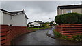
Turnberry Avenue
Houses in Turnberry Avenue, Newton Mearns.
Image: © Peter Mackenzie
Taken: 10 Sep 2018
0.19 miles
2

Mearns Castle Trig Point
The trig point is situated beside Mearns Castle High School and from here there is a good view over Newton Mearns towards the Campsie Fells in the distance.
Image: © G Laird
Taken: 1 Jan 2013
0.20 miles