IMAGES TAKEN NEAR TO
Windsor Avenue, GLASGOW, G77 5NU
Introduction
This page details the photographs taken nearby to Windsor Avenue, G77 5NU by members of the Geograph project.
The Geograph project started in 2005 with the aim of publishing, organising and preserving representative images for every square kilometre of Great Britain, Ireland and the Isle of Man.

There are currently over 7.5m images from over14,400 individuals and you can help contribute to the project by visiting https://www.geograph.org.uk
Image Map
Images are licensed for reuse under creativecommons.org/licenses/by-sa/2.0
Notes
- Clicking on the map will re-center to the selected point.
- The higher the marker number, the further away the image location is from the centre of the postcode.
Image Listing (10 Images Found)
Images are licensed for reuse under creativecommons.org/licenses/by-sa/2.0
Image
Details
Distance
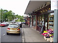
4
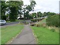
Approaching footbridge over Broom Burn
From the pavement by Mearns Road.
Image: © Stephen Sweeney
Taken: 29 Jul 2009
0.21 miles
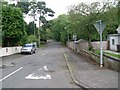
5

House and pillar box
Looking from Lochbroom Drive to the junction with Broompark Drive.
Image: © Richard Sutcliffe
Taken: 10 Dec 2018
0.21 miles
8
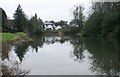
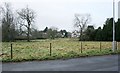
Pond beside Broompark Drive
Old maps show this as a curling pond.
Image: © Richard Sutcliffe
Taken: 10 Dec 2018
0.24 miles
9
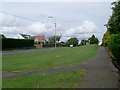
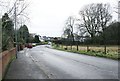
Mearns Road, Broom
Heading north towards the junction with Broom Road.
Image: © Stephen Sweeney
Taken: 29 Jul 2009
0.24 miles
10
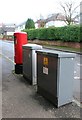
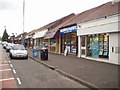
Street furniture, Lochbroom Drive
The pillar box is postbox number G77 1066D.
Image: © Richard Sutcliffe
Taken: 10 Dec 2018
0.24 miles