IMAGES TAKEN NEAR TO
Shawwood Crescent, GLASGOW, G77 5NA
Introduction
This page details the photographs taken nearby to Shawwood Crescent, G77 5NA by members of the Geograph project.
The Geograph project started in 2005 with the aim of publishing, organising and preserving representative images for every square kilometre of Great Britain, Ireland and the Isle of Man.

There are currently over 7.5m images from over14,400 individuals and you can help contribute to the project by visiting https://www.geograph.org.uk
Image Map
Images are licensed for reuse under creativecommons.org/licenses/by-sa/2.0
Notes
- Clicking on the map will re-center to the selected point.
- The higher the marker number, the further away the image location is from the centre of the postcode.
Image Listing (11 Images Found)
Images are licensed for reuse under creativecommons.org/licenses/by-sa/2.0
Image
Details
Distance
1
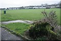
Open space, Mearns
Seen from the end of Newtonlea Avenue.
Image: © Richard Sutcliffe
Taken: 10 Dec 2018
0.05 miles
2
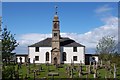
Mearns Parish Kirk
Mearns Parish Kirk originally dates from 1813, but as a result of major refurbishment in 1932 and again in 2002 it is still an extremely attractive and intimate place of worship with congregation approaching 900.
Image: © Gordon Wilson
Taken: 28 May 2006
0.06 miles
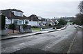
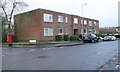
3
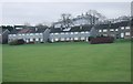
Houses, Mearns
The nearest properties are on Shawwood Crescent. The ones behind are on Shawhill Crescent.
Image: © Richard Sutcliffe
Taken: 10 Dec 2018
0.08 miles
4
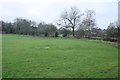
Edge of open area, Mearns
The trees follow the field boundary.
Image: © Richard Sutcliffe
Taken: 10 Dec 2018
0.09 miles
5
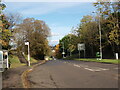
Mearns Road at Waterfoot Road
Mearns Road climbs uphill here as it approaches the traffic lights at the junction with Waterfoot Road.
Image: © Alec MacKinnon
Taken: 18 Oct 2022
0.10 miles
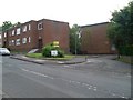
6
Shawfarm Apartments
At the end of Newtonlea Avenue.
Image: © Richard Sutcliffe
Taken: 10 Dec 2018
0.13 miles
8
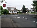
Stop line at end of Firwood Road
Stop lines are much less common than give ways in this area.
Image: © Stephen Sweeney
Taken: 29 Jul 2009
0.20 miles
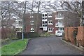
9
Firwood Court
Residential flats just off Firwood Road, Newton Mearns.
Image: © Stephen Sweeney
Taken: 29 Jul 2009
0.22 miles
10
Flats on Firwood Road
The block of flats is called Firwood Court. Newtonlea Avenue is on the left. The pillarbox is postbox number G77 1040D.
Image: © Richard Sutcliffe
Taken: 10 Dec 2018
0.23 miles