IMAGES TAKEN NEAR TO
Blackwood Avenue, GLASGOW, G77 5JY
Introduction
This page details the photographs taken nearby to Blackwood Avenue, G77 5JY by members of the Geograph project.
The Geograph project started in 2005 with the aim of publishing, organising and preserving representative images for every square kilometre of Great Britain, Ireland and the Isle of Man.

There are currently over 7.5m images from over14,400 individuals and you can help contribute to the project by visiting https://www.geograph.org.uk
Image Map
Images are licensed for reuse under creativecommons.org/licenses/by-sa/2.0
Notes
- Clicking on the map will re-center to the selected point.
- The higher the marker number, the further away the image location is from the centre of the postcode.
Image Listing (6 Images Found)
Images are licensed for reuse under creativecommons.org/licenses/by-sa/2.0
Image
Details
Distance
1
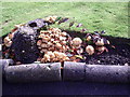
Fungi X2
The brackets are either Coriolus versicolor or Bjerkandera adusta - difficult to tell without a closer look at the specimen. The toadstools are probably a species of inkcap - Coprinus - C. micaceus is common on stumps and buried wood.
Thanks to M J Richardson for fungi info.
Image: © Alan Murray Walsh
Taken: 19 Aug 2008
0.18 miles
3
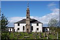
Mearns Parish Kirk
Mearns Parish Kirk originally dates from 1813, but as a result of major refurbishment in 1932 and again in 2002 it is still an extremely attractive and intimate place of worship with congregation approaching 900.
Image: © Gordon Wilson
Taken: 28 May 2006
0.20 miles
5
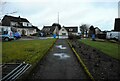
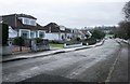
Houses on Broomfield Avenue
The path links the street with Waterfoot Road behind the camera.
Image: © Richard Sutcliffe
Taken: 15 Feb 2023
0.24 miles
6
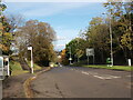
Mearns Road at Waterfoot Road
Mearns Road climbs uphill here as it approaches the traffic lights at the junction with Waterfoot Road.
Image: © Alec MacKinnon
Taken: 18 Oct 2022
0.25 miles