IMAGES TAKEN NEAR TO
Broomburn Drive, GLASGOW, G77 5JJ
Introduction
This page details the photographs taken nearby to Broomburn Drive, G77 5JJ by members of the Geograph project.
The Geograph project started in 2005 with the aim of publishing, organising and preserving representative images for every square kilometre of Great Britain, Ireland and the Isle of Man.

There are currently over 7.5m images from over14,400 individuals and you can help contribute to the project by visiting https://www.geograph.org.uk
Image Map
Images are licensed for reuse under creativecommons.org/licenses/by-sa/2.0
Notes
- Clicking on the map will re-center to the selected point.
- The higher the marker number, the further away the image location is from the centre of the postcode.
Image Listing (13 Images Found)
Images are licensed for reuse under creativecommons.org/licenses/by-sa/2.0
Image
Details
Distance
1
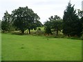
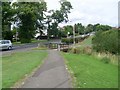
Trees surrounding Broom Burn
Seen from Dunure Place.
Image: © Stephen Sweeney
Taken: 29 Jul 2009
0.13 miles
2
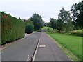
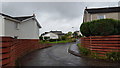
Dunure Place, Broom
Small side street just off Mearns Road.
Image: © Stephen Sweeney
Taken: 29 Jul 2009
0.15 miles
4
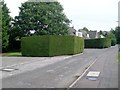
Oddly square hedge, Dunure Place
Several of the hedges on this street were cut this way.
Image: © Stephen Sweeney
Taken: 29 Jul 2009
0.18 miles
5
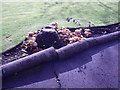
Approaching footbridge over Broom Burn
From the pavement by Mearns Road.
Image: © Stephen Sweeney
Taken: 29 Jul 2009
0.18 miles
6
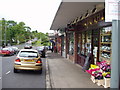
Turnberry Avenue
Houses in Turnberry Avenue, Newton Mearns.
Image: © Peter Mackenzie
Taken: 10 Sep 2018
0.18 miles
7
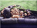
Fungi X2
The brackets are either Coriolus versicolor or Bjerkandera adusta - difficult to tell without a closer look at the specimen. The toadstools are probably a species of inkcap - Coprinus - C. micaceus is common on stumps and buried wood.
Thanks to M J Richardson for fungi info.
Image: © Alan Murray Walsh
Taken: 19 Aug 2008
0.20 miles
9
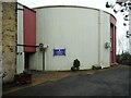
Maxwell Mearns Castle Parish Church
A church built on a circular floor plan adjacent to and attached to Mearns Castle, by Walter Ramsay Architects, built in 1971.
'In 1970 the congregation of Maxwell Church Pollok Street, Glasgow were forced to find a new site for their church due to the construction of the Kingston Bridge. It was decided that a new church should be built adjacent to Mearns Castle.
The congregation held services in the Mearns Castle hall until the church, Maxwell Mearns Castle Parish Church of Scotland, was completed. The church is attached to the castle but the castle itself is no longer used by the church.' (Information from Mearns History Group https://mearnshistory.org.uk/index.php/history/castles/mearns-castle ).
Image: © Richard Sutcliffe
Taken: 15 Feb 2023
0.24 miles
10
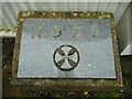
Date stone
A foundation stone for the Maxwell Mearns Castle Parish Church, dated 1971.
Image: © Richard Sutcliffe
Taken: 15 Feb 2023
0.24 miles