IMAGES TAKEN NEAR TO
Lawfield Avenue, GLASGOW, G77 5EG
Introduction
This page details the photographs taken nearby to Lawfield Avenue, G77 5EG by members of the Geograph project.
The Geograph project started in 2005 with the aim of publishing, organising and preserving representative images for every square kilometre of Great Britain, Ireland and the Isle of Man.

There are currently over 7.5m images from over14,400 individuals and you can help contribute to the project by visiting https://www.geograph.org.uk
Image Map
Images are licensed for reuse under creativecommons.org/licenses/by-sa/2.0
Notes
- Clicking on the map will re-center to the selected point.
- The higher the marker number, the further away the image location is from the centre of the postcode.
Image Listing (4 Images Found)
Images are licensed for reuse under creativecommons.org/licenses/by-sa/2.0
Image
Details
Distance
1
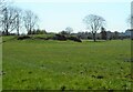
Rocky outcrop
A rocky outcrop in a field just south of Greenbank Garden. Possibly a small disused quarry.
Image: © Richard Sutcliffe
Taken: 21 Apr 2023
0.15 miles
2
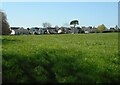
The edge of Whitecraigs
Seen from the woodland walk at Greenside Garden.
Image: © Richard Sutcliffe
Taken: 21 Apr 2023
0.17 miles
3
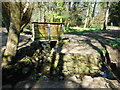
Bridge over drainage ditch
The edges of the ditch are well-built where two drainage channels meet.
Image: © Richard Sutcliffe
Taken: 21 Apr 2023
0.21 miles