IMAGES TAKEN NEAR TO
Beech Avenue, GLASGOW, G77 5BH
Introduction
This page details the photographs taken nearby to Beech Avenue, G77 5BH by members of the Geograph project.
The Geograph project started in 2005 with the aim of publishing, organising and preserving representative images for every square kilometre of Great Britain, Ireland and the Isle of Man.

There are currently over 7.5m images from over14,400 individuals and you can help contribute to the project by visiting https://www.geograph.org.uk
Image Map
Images are licensed for reuse under creativecommons.org/licenses/by-sa/2.0
Notes
- Clicking on the map will re-center to the selected point.
- The higher the marker number, the further away the image location is from the centre of the postcode.
Image Listing (5 Images Found)
Images are licensed for reuse under creativecommons.org/licenses/by-sa/2.0
Image
Details
Distance
1
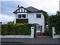
107 Beech Avenue Newton Mearns
In 1968 a lorry crashed into the front RHS of this house demolishing the porch: it was only the cellar that save the house from further damage
Image: © Ian Whyte
Taken: 11 May 2007
0.08 miles
2
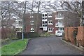
Shawfarm Apartments
At the end of Newtonlea Avenue.
Image: © Richard Sutcliffe
Taken: 10 Dec 2018
0.18 miles
3
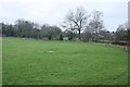
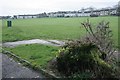
Edge of open area, Mearns
The trees follow the field boundary.
Image: © Richard Sutcliffe
Taken: 10 Dec 2018
0.19 miles
4
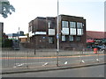
Lloyds TSB Scotland
Bank on Ayr Road, Newton Mearns [A77].
Image: © M J Richardson
Taken: 26 Jun 2013
0.20 miles
5
Open space, Mearns
Seen from the end of Newtonlea Avenue.
Image: © Richard Sutcliffe
Taken: 10 Dec 2018
0.22 miles