IMAGES TAKEN NEAR TO
Westerfield Road, GLASGOW, G76 9HS
Introduction
This page details the photographs taken nearby to Westerfield Road, G76 9HS by members of the Geograph project.
The Geograph project started in 2005 with the aim of publishing, organising and preserving representative images for every square kilometre of Great Britain, Ireland and the Isle of Man.

There are currently over 7.5m images from over14,400 individuals and you can help contribute to the project by visiting https://www.geograph.org.uk
Image Map
Images are licensed for reuse under creativecommons.org/licenses/by-sa/2.0
Notes
- Clicking on the map will re-center to the selected point.
- The higher the marker number, the further away the image location is from the centre of the postcode.
Image Listing (3 Images Found)
Images are licensed for reuse under creativecommons.org/licenses/by-sa/2.0
Image
Details
Distance
1
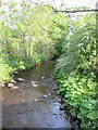
Kittoch Water
Kittoch Water from the bridge between Philipshill Cemetery and Carmunock.
Image: © Dannie Calder
Taken: 1 Jun 2003
0.04 miles
2
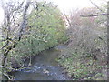
Kittoch Water
Kittoch Water is a tributary of the White Cart Water. Here we are looking down-river from the road bridge on Waterbank Road.
Image: © G Laird
Taken: 29 Oct 2013
0.08 miles
3

Across the fields to Westerfield Road
From the A727.
Image: © Stephen Sweeney
Taken: 16 Sep 2009
0.13 miles