IMAGES TAKEN NEAR TO
Carmunnock, Clarkston, GLASGOW, G76 9EZ
Introduction
This page details the photographs taken nearby to G76 9EZ by members of the Geograph project.
The Geograph project started in 2005 with the aim of publishing, organising and preserving representative images for every square kilometre of Great Britain, Ireland and the Isle of Man.

There are currently over 7.5m images from over14,400 individuals and you can help contribute to the project by visiting https://www.geograph.org.uk
Image Map
Images are licensed for reuse under creativecommons.org/licenses/by-sa/2.0
Notes
- Clicking on the map will re-center to the selected point.
- The higher the marker number, the further away the image location is from the centre of the postcode.
Image Listing (4 Images Found)
Images are licensed for reuse under creativecommons.org/licenses/by-sa/2.0
Image
Details
Distance
1
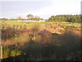
Muir Farm
Muir Farm viewed across disused reservoir and Cathkin Braes Golf Course.
Image: © Iain Thompson
Taken: 27 Dec 2005
0.02 miles
2
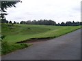
Cathkin Braes Golf Course
Looking in on the road off Cathkin Road.
Image: © Stephen Sweeney
Taken: 16 Sep 2009
0.20 miles
3
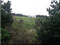
Forestry by the B759
Looking to the forest by Cathkin Braes Golf Course from Cathkin Road.
Image: © Stephen Sweeney
Taken: 16 Sep 2009
0.21 miles
4
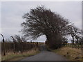
Trees by a country road
This single-track road runs east roughly from Carmunnock, one of a network of such wee roads just north of East Kilbride. The fencing at the left-hand side is intended to keep people out of a small reservoir but is now far too dilapidated to be effective.
Image: © Alec MacKinnon
Taken: 14 Mar 2015
0.24 miles