IMAGES TAKEN NEAR TO
Woodland Gardens, GLASGOW, G76 9AF
Introduction
This page details the photographs taken nearby to Woodland Gardens, G76 9AF by members of the Geograph project.
The Geograph project started in 2005 with the aim of publishing, organising and preserving representative images for every square kilometre of Great Britain, Ireland and the Isle of Man.

There are currently over 7.5m images from over14,400 individuals and you can help contribute to the project by visiting https://www.geograph.org.uk
Image Map
Images are licensed for reuse under creativecommons.org/licenses/by-sa/2.0
Notes
- Clicking on the map will re-center to the selected point.
- The higher the marker number, the further away the image location is from the centre of the postcode.
Image Listing (16 Images Found)
Images are licensed for reuse under creativecommons.org/licenses/by-sa/2.0
Image
Details
Distance
1
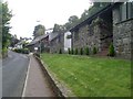
Housing in Carmunnock
On Busby Road.
Image: © Stephen Sweeney
Taken: 16 Sep 2009
0.10 miles
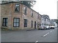
3
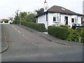
Bankhead Road
Steep residential street in Carmunnock.
Image: © Stephen Sweeney
Taken: 16 Sep 2009
0.16 miles
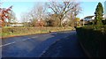
5
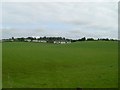
Carmunnock from the Bypass
Looking to houses on Woodside Road.
Image: © Stephen Sweeney
Taken: 16 Sep 2009
0.16 miles
8
New sign at start of Picketlaw Farm Road
For the housing development taking place in the area.
Image: © Stephen Sweeney
Taken: 16 Sep 2009
0.19 miles
9
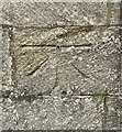
OS Published Abstract Bolt - Carmunnock, Church
https://www.bench-marks.org.uk/bm28302
Image: © thejackrustles
Taken: 15 May 2022
0.20 miles
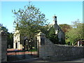
10
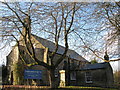
Carmunnock Parish Church (The Kirk o' the Braes)
Situated at the corner of Kirk Road and Busby Road in Carmunnock.
Image: © G Laird
Taken: 28 Nov 2012
0.20 miles