IMAGES TAKEN NEAR TO
Woodyett Park, GLASGOW, G76 8SJ
Introduction
This page details the photographs taken nearby to Woodyett Park, G76 8SJ by members of the Geograph project.
The Geograph project started in 2005 with the aim of publishing, organising and preserving representative images for every square kilometre of Great Britain, Ireland and the Isle of Man.

There are currently over 7.5m images from over14,400 individuals and you can help contribute to the project by visiting https://www.geograph.org.uk
Image Map
Images are licensed for reuse under creativecommons.org/licenses/by-sa/2.0
Notes
- Clicking on the map will re-center to the selected point.
- The higher the marker number, the further away the image location is from the centre of the postcode.
Image Listing (17 Images Found)
Images are licensed for reuse under creativecommons.org/licenses/by-sa/2.0
Image
Details
Distance
1
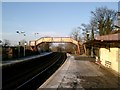
Busby Railway Station
Looking towards Clarkston at 340 degrees.
Image: © Graham Kelly
Taken: 29 Jan 2006
0.12 miles
3
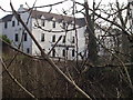
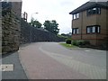
Busby Hotel
Field Road, Busby
Photo taken through the trees from the bridge on Main St over the River Cart.
Image: © G McK
Taken: 4 Feb 2006
0.14 miles
5
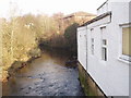
Old mill on River Cart
The old mill building is now offices on the edge of the River Cart, Busby
Image: © G McK
Taken: 4 Feb 2006
0.16 miles
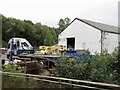
7
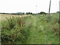
Track, Busby
Beside the railway and shown on Naturescot's core path map. I got through but it was a struggle. The East Renfrewshire council area is a bit of a black hole for core paths. This was the first of three dud paths today.
Image: © Richard Webb
Taken: 17 Aug 2022
0.18 miles
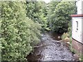
8
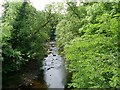
White Cart Water
From Busby Bridge.
Image: © Stephen Sweeney
Taken: 13 Jun 2009
0.18 miles
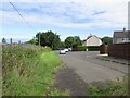
9
Wall alongside Busby station
At Westerton Avenue.
Image: © Stephen Sweeney
Taken: 13 Jun 2009
0.19 miles
10
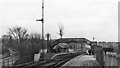
Busby Station
View southward, towards East Kilbride; ex-caledonian Glasgow (Central) - Pollokshaws - East Kilbride line, formerly (until 1914) extended to Hunthill Jct. and Hamilton.
Image: © Ben Brooksbank
Taken: 21 Mar 1970
0.21 miles