IMAGES TAKEN NEAR TO
Eaglesham Road, GLASGOW, G76 8RP
Introduction
This page details the photographs taken nearby to Eaglesham Road, G76 8RP by members of the Geograph project.
The Geograph project started in 2005 with the aim of publishing, organising and preserving representative images for every square kilometre of Great Britain, Ireland and the Isle of Man.

There are currently over 7.5m images from over14,400 individuals and you can help contribute to the project by visiting https://www.geograph.org.uk
Image Map
Images are licensed for reuse under creativecommons.org/licenses/by-sa/2.0
Notes
- Clicking on the map will re-center to the selected point.
- The higher the marker number, the further away the image location is from the centre of the postcode.
Image Listing (16 Images Found)
Images are licensed for reuse under creativecommons.org/licenses/by-sa/2.0
Image
Details
Distance
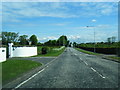
2
Housecraigs
A converted farmhouse on the Eaglesham Road. The picture was taken from Flenders Road
Image: © G McK
Taken: 9 Jun 2005
0.07 miles
3
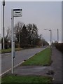
Bus stop on Eaglesham Road
The bus stop, just after the entrance to Williamwood High School, is served by the No. 44 bus as it heads south to Eaglesham.
Image: © Alec MacKinnon
Taken: 28 Nov 2009
0.10 miles
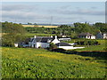
4
Millerston
Small hamlet just south of Busby.
Image: © G Laird
Taken: 1 Jan 2013
0.10 miles
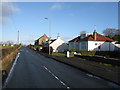
5
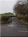
Junction of Low Flenders Road and Eaglesham Road
The picture looks along Low Flenders Road.
Image: © Alec MacKinnon
Taken: 28 Nov 2009
0.10 miles
6
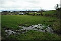
Damp corner of a field
Looking down the slope towards Housecraigs.
Image: © Richard Sutcliffe
Taken: 15 Feb 2023
0.12 miles
7
The site of the new Williamwood High School
This will be the new school in a year's time
Image: © G McK
Taken: 9 Jun 2005
0.13 miles
8
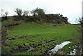
Flenders Rock
A small outcrop of olivine-macrophyric basalt (according to the British Geological Survey map) - probably a volcanic plug, beside Low Flenders Road.
Image: © Richard Sutcliffe
Taken: 15 Feb 2023
0.15 miles
9
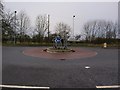
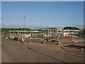
Roundabout at Williamwood School
The construction in 2005 of the new Williamwood School buildings on the edge of Busby also involved the construction of this roundabout.
Image: © Alec MacKinnon
Taken: 28 Nov 2009
0.15 miles
10
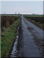
Flenders Road
The picture looks along the winding, narrow Flenders Road as it runs westward from the Eaglesham Road to Mearns Road.
Image: © Alec MacKinnon
Taken: 28 Nov 2009
0.17 miles