IMAGES TAKEN NEAR TO
The Crescent, GLASGOW, G76 8HT
Introduction
This page details the photographs taken nearby to The Crescent, G76 8HT by members of the Geograph project.
The Geograph project started in 2005 with the aim of publishing, organising and preserving representative images for every square kilometre of Great Britain, Ireland and the Isle of Man.

There are currently over 7.5m images from over14,400 individuals and you can help contribute to the project by visiting https://www.geograph.org.uk
Image Map
Images are licensed for reuse under creativecommons.org/licenses/by-sa/2.0
Notes
- Clicking on the map will re-center to the selected point.
- The higher the marker number, the further away the image location is from the centre of the postcode.
Image Listing (15 Images Found)
Images are licensed for reuse under creativecommons.org/licenses/by-sa/2.0
Image
Details
Distance
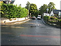
1
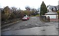
Private road
Unmetalled private road off The Crescent, Busby.
Image: © Richard Sutcliffe
Taken: 17 Dec 2019
0.02 miles
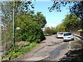
2
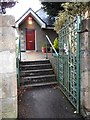
Entrance to the BBC
The BBC in this instance is the Busby Bowling Club.
Image: © Richard Sutcliffe
Taken: 17 Dec 2019
0.03 miles
4
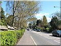
East Kilbride Road, Busby
The picture was taken from a point opposite the junction with South Road.
Image: © Lairich Rig
Taken: 29 Apr 2005
0.08 miles
5
Carmunnock Road
Carmunnock Road as viewed from East Kilbride Road in Busby.
Image: © Andrew Reid
Taken: 8 Sep 2011
0.11 miles
6
Easter Road, Busby
The photograph was taken from the point, not far from the railway bridge, where Easter Road branches off from the main road through Busby.
Image: © Lairich Rig
Taken: 29 Apr 2005
0.12 miles
7
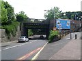
Railway bridge over East Kilbride Road
Next to Busby station.
Image: © Stephen Sweeney
Taken: 13 Jun 2009
0.13 miles
8
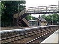
Busby railway station
On the Glasgow to East Kilbride line.
Image: © Stephen Sweeney
Taken: 13 Jun 2009
0.13 miles
9
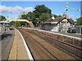
Busby railway station, East Renfrewshire
Opened in 1866 by the Busby Railway which became part of the Caledonian Railway empire, this is on the line from Glasgow Central to East Kilbride. View north towards Clarkston and Glasgow.
Image: © Nigel Thompson
Taken: 12 Oct 2013
0.14 miles
10
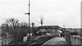
Busby Station
View southward, towards East Kilbride; ex-caledonian Glasgow (Central) - Pollokshaws - East Kilbride line, formerly (until 1914) extended to Hunthill Jct. and Hamilton.
Image: © Ben Brooksbank
Taken: 21 Mar 1970
0.14 miles