IMAGES TAKEN NEAR TO
Stamperland Gardens, GLASGOW, G76 8HQ
Introduction
This page details the photographs taken nearby to Stamperland Gardens, G76 8HQ by members of the Geograph project.
The Geograph project started in 2005 with the aim of publishing, organising and preserving representative images for every square kilometre of Great Britain, Ireland and the Isle of Man.

There are currently over 7.5m images from over14,400 individuals and you can help contribute to the project by visiting https://www.geograph.org.uk
Image Map
Images are licensed for reuse under creativecommons.org/licenses/by-sa/2.0
Notes
- Clicking on the map will re-center to the selected point.
- The higher the marker number, the further away the image location is from the centre of the postcode.
Image Listing (21 Images Found)
Images are licensed for reuse under creativecommons.org/licenses/by-sa/2.0
Image
Details
Distance
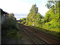
3

Clarkston station
View SE, towards East Kilbride: ex-Caledonian Railway, Glasgow Central - Busby - East Kilbride line.
Image: © Ben Brooksbank
Taken: 3 Jul 1994
0.17 miles
4
Clarkston railway station
Looking towards East Kilbride from the Glasgow end of platform 1.
Image: © Richard Vince
Taken: 12 Sep 2022
0.18 miles
5

Clarkston railway station, South Lanarkshire
Opened in 1866 by the Busby Railway which became part of the Caledonian Railway empire, this is on the line from Glasgow Central to East Kilbride. View south east towards Busby and East Kilbride.
Image: © Nigel Thompson
Taken: 12 Oct 2013
0.18 miles
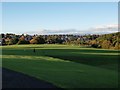
6
Overlee Pavilion
The pavilion is used for the usual array of sports activities, adult education classes, etc. The ground falls away steeply beyond the pavilion, down to the sports pitches, and the wood at the right-hand side actually lies on the other side of the River Cart.
Image: © Alec MacKinnon
Taken: 2 Dec 2010
0.18 miles
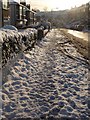
7

Looking down Busby Road
Busby Road approaching Clarkston Toll can see heavy traffic in the rush hour, but it was very quiet on this particular Sunday afternoon.
Image: © Alec MacKinnon
Taken: 3 Oct 2010
0.19 miles
8
Railway north west from Clarkston station
Looking towards Glasgow.
Image: © Richard Vince
Taken: 12 Sep 2022
0.20 miles
9

Busby Road, Clarkston.
Busy shopping area at Clarkston Toll.
Image: © John McLeish
Taken: 24 May 2006
0.21 miles
10
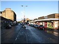
Busby Road, Clarkston (A727)
The main shopping centre of Clarkston.
The shops on the right hand side are on the site of the Clarkston Toll disaster of 21st October 1971 when 22 people were killed. A lot of background information can be found in the Scotsman's Website http://www.scotsman.com/the-scotsman/scotland/forty-years-on-remembering-the-clarkston-toll-disaster-1-1915939 and the Daily Record's Website http://www.dailyrecord.co.uk/news/real-life/toll-disaster-victims-daughter-relives-1082125 both recalling the 40 year anniversary of the event. It was the second major disaster in the Glasgow area that year. On the 2nd January 1971, 66 people died in the Ibrox disaster.
Image: © G Laird
Taken: 1 Jan 2013
0.21 miles