IMAGES TAKEN NEAR TO
Stamperland Gardens, GLASGOW, G76 8HH
Introduction
This page details the photographs taken nearby to Stamperland Gardens, G76 8HH by members of the Geograph project.
The Geograph project started in 2005 with the aim of publishing, organising and preserving representative images for every square kilometre of Great Britain, Ireland and the Isle of Man.

There are currently over 7.5m images from over14,400 individuals and you can help contribute to the project by visiting https://www.geograph.org.uk
Image Map
Images are licensed for reuse under creativecommons.org/licenses/by-sa/2.0
Notes
- Clicking on the map will re-center to the selected point.
- The higher the marker number, the further away the image location is from the centre of the postcode.
Image Listing (8 Images Found)
Images are licensed for reuse under creativecommons.org/licenses/by-sa/2.0
Image
Details
Distance
2
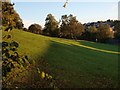
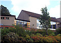
Open space behind Clarkston Library
Grassy slopes lie between Clarkston Library and the car park, and Stamperland Hill.
Image: © Alec MacKinnon
Taken: 3 Oct 2010
0.21 miles
5
Clarkston Library, East Renfrewshire
The local library situated at Clarkston Toll.
Image: © John McLeish
Taken: 24 May 2006
0.24 miles
6
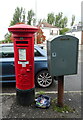
George V postbox on the B767, Stamperland
Postbox No. G76 951.
Image: © JThomas
Taken: 14 Sep 2021
0.24 miles
7

Defibrillator
On the wall outside the entrance to the Clarkston Community Centre mosque Image
Image: © Richard Sutcliffe
Taken: 13 Jul 2024
0.24 miles
8

Clarkston station
View SE, towards East Kilbride: ex-Caledonian Railway, Glasgow Central - Busby - East Kilbride line.
Image: © Ben Brooksbank
Taken: 3 Jul 1994
0.25 miles