IMAGES TAKEN NEAR TO
Linwood Avenue, GLASGOW, G76 8BZ
Introduction
This page details the photographs taken nearby to Linwood Avenue, G76 8BZ by members of the Geograph project.
The Geograph project started in 2005 with the aim of publishing, organising and preserving representative images for every square kilometre of Great Britain, Ireland and the Isle of Man.

There are currently over 7.5m images from over14,400 individuals and you can help contribute to the project by visiting https://www.geograph.org.uk
Image Map
Images are licensed for reuse under creativecommons.org/licenses/by-sa/2.0
Notes
- Clicking on the map will re-center to the selected point.
- The higher the marker number, the further away the image location is from the centre of the postcode.
Image Listing (21 Images Found)
Images are licensed for reuse under creativecommons.org/licenses/by-sa/2.0
Image
Details
Distance
1
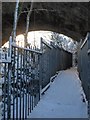
Footpath under the railway viaduct
The picture shows the narrow footpath that passes under the railway viaduct where it crosses the Cart, just after leaving Clarkston station towards East Kilbride. On the left hand side there is a precipitous drop of many tens of feet to the river, which no doubt makes that high fence almost essential for safety.
Image: © Alec MacKinnon
Taken: 2 Dec 2010
0.06 miles
2
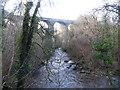
Railway viaduct over the White Cart Water
The viaduct carries the Glasgow South Western Line between Busby and Clarkston railway stations.
Image: © G Laird
Taken: 1 Jan 2013
0.08 miles
3
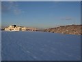
Overlee Pavilion
The pavilion is used for the usual array of sports activities, adult education classes, etc. The ground falls away steeply beyond the pavilion, down to the sports pitches, and the wood at the right-hand side actually lies on the other side of the River Cart.
Image: © Alec MacKinnon
Taken: 2 Dec 2010
0.09 miles
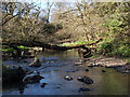
4
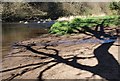
Tiny beach on the White Cart
A tree behind the photographer casts a shadow on the tiny, sandy beach on the White Cart, as it passes through Busby Glen.
Image: © Alec MacKinnon
Taken: 18 Apr 2014
0.14 miles
5
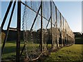
Fence next Overlee football pitches
In the late afternoon the sunlight reflects off the fence that runs along the side of the football pitches in Overlee playing fields.
Image: © Alec MacKinnon
Taken: 3 Oct 2010
0.14 miles
6
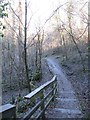
Path and Steps in Busby Glen
The northern end of the loop path in Busby Glen beside the White Cart Water.
Image: © G Laird
Taken: 1 Jan 2013
0.15 miles
7
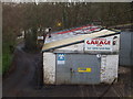
Lower Mill Garage, Busby
Just below the main road from Clarkston to Busby
Image: © G McK
Taken: 4 Feb 2006
0.17 miles
8
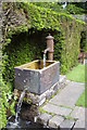
Greenbank Garden
Water feature in Greenbank Garden, Clarkston. The Garden is a National Trust for Scotland property.
Image: © David McMumm
Taken: 9 Jun 2003
0.18 miles
9

Busby Road at Sheddens Roundabout
The A727 continues to the left, while the B727 is to the right.
Image: © Richard Sutcliffe
Taken: 17 Dec 2019
0.18 miles
10
Tree fallen across the Kittoch Water
A tree has fallen across the Kittoch Water, providing a temporary bridge for the daring.
Image: © Alec MacKinnon
Taken: 18 Apr 2014
0.18 miles