IMAGES TAKEN NEAR TO
Victoria Crescent, GLASGOW, G76 8BP
Introduction
This page details the photographs taken nearby to Victoria Crescent, G76 8BP by members of the Geograph project.
The Geograph project started in 2005 with the aim of publishing, organising and preserving representative images for every square kilometre of Great Britain, Ireland and the Isle of Man.

There are currently over 7.5m images from over14,400 individuals and you can help contribute to the project by visiting https://www.geograph.org.uk
Image Map
Images are licensed for reuse under creativecommons.org/licenses/by-sa/2.0
Notes
- Clicking on the map will re-center to the selected point.
- The higher the marker number, the further away the image location is from the centre of the postcode.
Image Listing (30 Images Found)
Images are licensed for reuse under creativecommons.org/licenses/by-sa/2.0
Image
Details
Distance
1

Busby Road at Sheddens Roundabout
The A727 continues to the left, while the B727 is to the right.
Image: © Richard Sutcliffe
Taken: 17 Dec 2019
0.07 miles
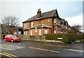
2
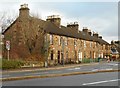
Terraced houses, Busby Road
Beside Sheddens Roundabout.
Image: © Richard Sutcliffe
Taken: 17 Dec 2019
0.08 miles
3
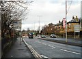
Busby Road
The A727 looking north.
Image: © Richard Sutcliffe
Taken: 17 Dec 2019
0.11 miles
4
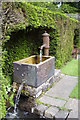
Greenbank Garden
Water feature in Greenbank Garden, Clarkston. The Garden is a National Trust for Scotland property.
Image: © David McMumm
Taken: 9 Jun 2003
0.11 miles
6
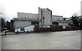
St. Joseph's R.C. Church, Clarkston
Seen from Cecil Street. See https://www.geograph.org.uk/photo/2183263 for an earlier view from Busby Road.
Image: © Richard Sutcliffe
Taken: 17 Dec 2019
0.12 miles
7
Carolside Medical Centre
At the junction of Busby Road and Cecil Street.
Image: © Richard Sutcliffe
Taken: 17 Dec 2019
0.12 miles
8
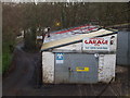
Lower Mill Garage, Busby
Just below the main road from Clarkston to Busby
Image: © G McK
Taken: 4 Feb 2006
0.13 miles
9
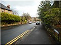
Cecil Street, Clarkston
Looking towards Busby Road.
Image: © Richard Sutcliffe
Taken: 17 Dec 2019
0.13 miles
10
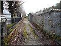
Lane behind St. Joseph's church
The lane runs between St. Joseph's RC Church on the left and the back of houses on Carolside Avenue.
Image: © Richard Sutcliffe
Taken: 17 Dec 2019
0.13 miles