IMAGES TAKEN NEAR TO
Randolph Drive, GLASGOW, G76 8AT
Introduction
This page details the photographs taken nearby to Randolph Drive, G76 8AT by members of the Geograph project.
The Geograph project started in 2005 with the aim of publishing, organising and preserving representative images for every square kilometre of Great Britain, Ireland and the Isle of Man.

There are currently over 7.5m images from over14,400 individuals and you can help contribute to the project by visiting https://www.geograph.org.uk
Image Map
Images are licensed for reuse under creativecommons.org/licenses/by-sa/2.0
Notes
- Clicking on the map will re-center to the selected point.
- The higher the marker number, the further away the image location is from the centre of the postcode.
Image Listing (13 Images Found)
Images are licensed for reuse under creativecommons.org/licenses/by-sa/2.0
Image
Details
Distance
1
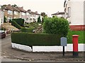
Cromarty Gardens, G76
Shows the location of Image
Image: © Mike Quinn
Taken: 21 Oct 2010
0.16 miles

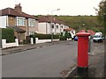
3
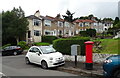
Houses on Cromarty Gardens
Showing position of Postbox No. G76 1131.
See Image] for postbox.
Image: © JThomas
Taken: 14 Sep 2021
0.19 miles
4

Defibrillator
On the wall outside the entrance to the Clarkston Community Centre mosque Image
Image: © Richard Sutcliffe
Taken: 13 Jul 2024
0.20 miles
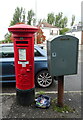
5
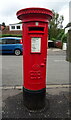
Edward VIII postbox on Monteith Drive
Postbox No. G76 1131.
See Image] for context.
Image: © JThomas
Taken: 14 Sep 2021
0.20 miles
6
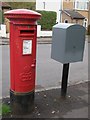
Edward VIII postbox, Monteith Drive / Cromarty Gardens, G76
Image: © Mike Quinn
Taken: 21 Oct 2010
0.21 miles
7

Edward VIII postbox, Monteith Drive / Cromarty Gardens, G76 - royal cipher
See Image
Image: © Mike Quinn
Taken: 21 Oct 2010
0.21 miles
9
George V postbox on the B767, Stamperland
Postbox No. G76 951.
Image: © JThomas
Taken: 14 Sep 2021
0.21 miles
10
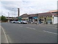
Clarkston Road shops
Between the two churches seen on the map.
Image: © Stephen Sweeney
Taken: 13 Jun 2009
0.22 miles