IMAGES TAKEN NEAR TO
Hillend Road, GLASGOW, G76 7TQ
Introduction
This page details the photographs taken nearby to Hillend Road, G76 7TQ by members of the Geograph project.
The Geograph project started in 2005 with the aim of publishing, organising and preserving representative images for every square kilometre of Great Britain, Ireland and the Isle of Man.

There are currently over 7.5m images from over14,400 individuals and you can help contribute to the project by visiting https://www.geograph.org.uk
Image Map
Images are licensed for reuse under creativecommons.org/licenses/by-sa/2.0
Notes
- Clicking on the map will re-center to the selected point.
- The higher the marker number, the further away the image location is from the centre of the postcode.
Image Listing (9 Images Found)
Images are licensed for reuse under creativecommons.org/licenses/by-sa/2.0
Image
Details
Distance
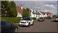
3
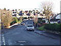
Hillend Rd
Taken at the junction of Hillend Crescent with Sundale Avenue further away.
Image: © G McK
Taken: 24 Dec 2005
0.18 miles
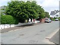
7
Low Flenders Road near Flenders Farm
A single-track road among the fields just south of Clarkston.
Image: © Alec MacKinnon
Taken: 17 Feb 2018
0.23 miles
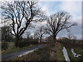
8
South edge of Clarkston
The picture looks from Eaglesham Road across the fields immediately south of Hillend Road, which in turn is the southern edge of the Clarkston area.
Image: © Alec MacKinnon
Taken: 10 Feb 2021
0.24 miles
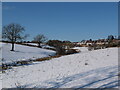
9
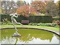
Greenbank Garden
The beautiful gardens of the National Trust for Scotland property on the south of Glasgow
Image: © G McK
Taken: 1 Nov 2003
0.25 miles