IMAGES TAKEN NEAR TO
Hillview Drive, GLASGOW, G76 7JH
Introduction
This page details the photographs taken nearby to Hillview Drive, G76 7JH by members of the Geograph project.
The Geograph project started in 2005 with the aim of publishing, organising and preserving representative images for every square kilometre of Great Britain, Ireland and the Isle of Man.

There are currently over 7.5m images from over14,400 individuals and you can help contribute to the project by visiting https://www.geograph.org.uk
Image Map
Images are licensed for reuse under creativecommons.org/licenses/by-sa/2.0
Notes
- Clicking on the map will re-center to the selected point.
- The higher the marker number, the further away the image location is from the centre of the postcode.
Image Listing (10 Images Found)
Images are licensed for reuse under creativecommons.org/licenses/by-sa/2.0
Image
Details
Distance
1

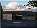
Spar, Clarkston
At the junction of Mearns Road and Benview Drive, Clarkston
Image: © G McK
Taken: 4 Feb 2006
0.10 miles
2
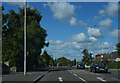
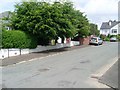
Mearns Road
This is Mearns Road as it passes through the suburb of Clarkston in Glasgow.
Image: © Malcolm Neal
Taken: 24 Sep 2022
0.13 miles


7

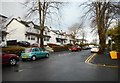
Station Master's House, Clarkston Station
Taken on Busby Road, Clarkston looking towards the Toll
Image: © G McK
Taken: 24 Dec 2005
0.23 miles
8
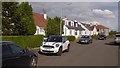
Houses, Carolside Avenue, Clarkston
Seen from the junction with Cecil Street.
Image: © Richard Sutcliffe
Taken: 17 Dec 2019
0.23 miles
10

Clarkston Toll,East renfrewshire.
Nightshot of the buildings at the toll.
Image: © John McLeish
Taken: 18 Oct 2006
0.24 miles