IMAGES TAKEN NEAR TO
Eaglesham, GLASGOW, G76 0PX
Introduction
This page details the photographs taken nearby to G76 0PX by members of the Geograph project.
The Geograph project started in 2005 with the aim of publishing, organising and preserving representative images for every square kilometre of Great Britain, Ireland and the Isle of Man.

There are currently over 7.5m images from over14,400 individuals and you can help contribute to the project by visiting https://www.geograph.org.uk
Image Map
Images are licensed for reuse under creativecommons.org/licenses/by-sa/2.0
Notes
- Clicking on the map will re-center to the selected point.
- The higher the marker number, the further away the image location is from the centre of the postcode.
Image Listing (9 Images Found)
Images are licensed for reuse under creativecommons.org/licenses/by-sa/2.0
Image
Details
Distance
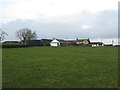
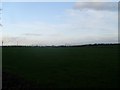
1
Floors Farm
From the farm road just off the main Floors Road.
Image: © Stephen Sweeney
Taken: 17 Nov 2009
0.02 miles
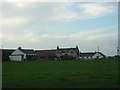
2
Floors Farm
South of Newton Mearns and just north of the minor road Floors Road.
Image: © G Laird
Taken: 3 Jan 2013
0.03 miles
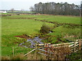
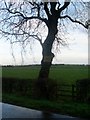
4
Field by Floors Farm
Looking east towards Windhill Farm.
Image: © Stephen Sweeney
Taken: 17 Nov 2009
0.09 miles
5
Sign on tree at Floors Farm
Advertising (if that's the right word) their local breed of sheep.
Image: © Stephen Sweeney
Taken: 17 Nov 2009
0.10 miles
6

Tilled field
In the farmland between Newton Mearns and Eaglesham, just north of the Humbie Road that runs between them. Floors Farm sits across the field at upper right.
Image: © Alec MacKinnon
Taken: 21 Jul 2020
0.13 miles
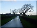
7
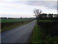
Single track road to Floors
National speed limit of 60mph applies. I wouldn't be brave enough to try it...
Image: © Stephen Sweeney
Taken: 17 Nov 2009
0.19 miles
8
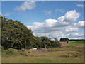
Wood beside Floors Road
The little wood sits beside Floors Road near its junction with the Humbie Road. Above the wood a buzzard circles.
Image: © Alec MacKinnon
Taken: 21 Jul 2020
0.19 miles