IMAGES TAKEN NEAR TO
Eaglesham, GLASGOW, G76 0PG
Introduction
This page details the photographs taken nearby to G76 0PG by members of the Geograph project.
The Geograph project started in 2005 with the aim of publishing, organising and preserving representative images for every square kilometre of Great Britain, Ireland and the Isle of Man.

There are currently over 7.5m images from over14,400 individuals and you can help contribute to the project by visiting https://www.geograph.org.uk
Image Map
Images are licensed for reuse under creativecommons.org/licenses/by-sa/2.0
Notes
- Clicking on the map will re-center to the selected point.
- The higher the marker number, the further away the image location is from the centre of the postcode.
Image Listing (9 Images Found)
Images are licensed for reuse under creativecommons.org/licenses/by-sa/2.0
Image
Details
Distance
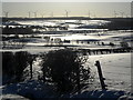
2
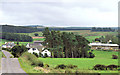
Nether Enoch
A view of the farm house and buildings in this rural setting near Eaglesham, East Renfrewshire.
Image: © John McLeish
Taken: 4 Sep 2006
0.02 miles
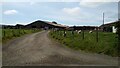
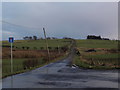
3
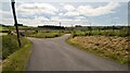
The parting of the ways
Left to Threepland; right to Carrot farm and an entrance to Whitelee Windfarm.
Image: © Gordon Brown
Taken: 30 Jun 2021
0.06 miles
4
Fork in the road at Nether Enoch
The minor road south of Eaglesham forks here. We look along the road that comes to an end at Threepland. To the right the road heads towards its end at Carrot Farm.
Image: © Alec MacKinnon
Taken: 3 Mar 2020
0.07 miles
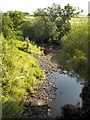
5
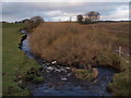
Ardoch Burn flowing away from South Bridge
Image: © Alec MacKinnon
Taken: 3 Mar 2020
0.10 miles
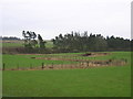
6
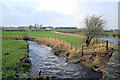
Ardoch Burn
This burn is a tributary of the White Cart Water. image taken near Eaglesham East Renfrewshire.
Image: © John McLeish
Taken: 23 Mar 2007
0.13 miles