IMAGES TAKEN NEAR TO
Millhall Road, GLASGOW, G76 0PD
Introduction
This page details the photographs taken nearby to Millhall Road, G76 0PD by members of the Geograph project.
The Geograph project started in 2005 with the aim of publishing, organising and preserving representative images for every square kilometre of Great Britain, Ireland and the Isle of Man.

There are currently over 7.5m images from over14,400 individuals and you can help contribute to the project by visiting https://www.geograph.org.uk
Image Map
Images are licensed for reuse under creativecommons.org/licenses/by-sa/2.0
Notes
- Clicking on the map will re-center to the selected point.
- The higher the marker number, the further away the image location is from the centre of the postcode.
Image Listing (16 Images Found)
Images are licensed for reuse under creativecommons.org/licenses/by-sa/2.0
Image
Details
Distance
1
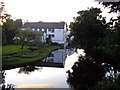
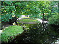
Reflections in a millpond
At Millhall House, outside Eaglesham.
Image: © Gordon Brown
Taken: 26 Aug 2019
0.01 miles
3
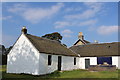
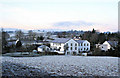
Millhall
John White established a cotton mill at Millhall Mill, previously a corn mill, on the Polnoon Water in 1822. The mill produced cotton wad for use in hospitals to bind wounds as well as spinning shuttle cord for power-looms and candle wicks. Ludovic Gavin bought the mill from John Whyte's creditors in 1837. The mill contained 620 spindles and employed 64 hands. The water wheel which was the equivalent to the power of 24 horses was located internally at the end of the mill indicated by the position of the sluices. Following Gavin's death, powerlooms were installed for weaving blankets and tweeds in an attempt to keep-up with technology however this and the carding machine that was installed at the Orry Mill http://www.geograph.org.uk/photo/1450337 in 1871 reduced the need for labour. In March 1851, part of the mill and a bridge downstream at Mains Farms were carried away when an embankment at Dunwan Dam burst, fortunately with no loss of life. Afterwards a weir was built across the burn. The New Statistical Account of Scotland notes that the wad produced at Millhall is 'of the most approved sort. Persons ought to be aware of that purchased in the shops with a glazed surface, strengthened by glue, as it is manufactured with arsenic to preserve it from insects, and often proves hurtful when applied to open wounds.' It appears likely that the dam and the alterations to the mill were made to convert it to a hydro-electric generating station in about 1900.
Image: © Kenneth Mallard
Taken: 9 Sep 2009
0.02 miles
4
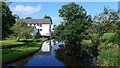
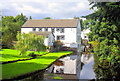
Restored Mill House.
Frosty morning image of Millhall Apartments, Polnoon, near Eglesham, East Renfrewshire.
Image: © John McLeish
Taken: 4 Feb 2006
0.03 miles
5
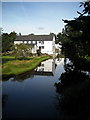
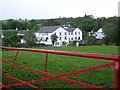
Millhall Apartments
A view of the restored old Mill House on the banks of the Ardoch Burn.
Image: © John McLeish
Taken: 17 Jul 2006
0.04 miles
6
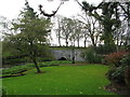
Polnoon Bridge
Road bridge across the Polnoon Water, a tributary of the White Cart Water, at Millhall.
Image: © G Laird
Taken: 31 Oct 2013
0.04 miles
9
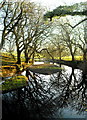
Polnoon Water at Polnoon Bridge
Reflections of trees surrounding Polnoon Water
Image: © Iain Thompson
Taken: 30 Dec 2008
0.08 miles